Posted by: James Wapotich | November 28, 2016

Trail Quest: Frémont’s Ridge

On Christmas Eve, 1846, Lieutenant Colonel John C. Frémont made his historic ascent along what is now known as Fremont Ridge during the Mexican-American War. Frémont and his men were en route to capture Santa Barbara, which was then still part of Mexico.

Starting from East Camino Cielo one can make a short day hike along a portion of Frémont’s route. The hike is about three miles round trip and includes some sweeping views of the San Rafael Mountains and Santa Ynez Valley.

To get to the trailhead from Santa Barbara, take State Route 154 to the top of the Santa Ynez Mountains. Turn right onto East Camino Cielo Road, and continue about two miles and look for an unpaved access road on the left with a metal gate that leads down the backside of the mountains. You’ll know if you’ve gone too far as a mile later you’ll arrive at the intersection with Painted Cave Road. Parking is available in the pullouts alongside the road near the gate.

John C Fremont Ridge Trail Los Laureles Canyon hike Santa Barbara east camino cielo San Rafael Mountains Los Padres National Forest

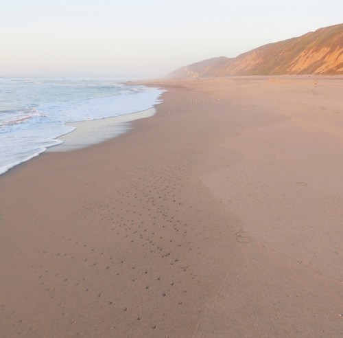
The San Rafael Mountains are seen from Fremont Ridge Trail

From the trailhead, the access road, also known as Fremont Ridge Trail, descends gradually through a mix of coast live oak and madrone. The views then open up back towards the top of the mountains and a stand of Coulter pines, a number of which are suffering from the drought.

As the road continues it settles in on the ridge and here, the views open up dramatically. Across Los Laureles Canyon one can see State Route 154, the Cold Spring arch bridge, Broadcast Peak, and the sweep of the Santa Ynez Valley, including what’s left of Lake Cachuma. Continuing in an arc, the panorama takes in the San Rafael Mountains stretching from Lookout Mountain to San Rafael Mountain.

Past this vista point, the road descends more rapidly downhill, eventually leveling out and arriving at a set of power lines. Here, the route Frémont used continues through private property and is closed to the public.

The steepness of the route in places and the healthy stands of chaparral on both sides of the road give some sense of what the climb might’ve been like for Frémont’s forces as they trudged uphill with their horses and artillery.

John Charles Frémont was born in Savannah, Georgia in 1813. In 1838, he joined U.S. Army Corps of Topographic Engineers, becoming a second lieutenant. Through the Corps he participated in a number of survey expeditions through the western territories the US had acquired as part of the 1803 Louisiana Purchase.

In 1841, he married Jessie Benton, whose father was Senator Thomas Hart Benton of Missouri. An influential Senator, Benton was a proponent of the expansionist movement and saw to it that Frémont was put in charge of a number of expeditions to survey and help open up the American West.

During his first expedition in 1842, Frémont met Kit Carson, who he enlisted as a guide. Frémont surveyed the area between the Missouri River and Rocky Mountains, and his subsequent survey report, which was published in various newspapers, garnered him celebrity status.

His second expedition in 1843, surveyed what would become the second half of the Oregon Trail. From Oregon, he continued south into Alta California, making a loop back through the Great Basin.

His third expedition west in 1845, was likely a pretense used by President Polk to send Frémont to California to be available should war break out with Mexico. In April 1846, the Mexican-American War began.

In July 1846, the US Navy captured Monterey, California. Commodore Robert F. Stockton was put in charge of land operations and appointed Frémont in charge of the California Battalion, which Frémont had helped organize with men from his survey expedition, volunteers from the short-lived Bear Flag Republic, and a group of Indians from Oregon.

Towards the end of 1846, Frémont left Monterey with 478 men and traveled south, bringing with them several wheeled cannons. On December 18, they arrived at William Dana’s adobe in Nipomo.

From there, they continued south, crossing the Santa Maria River and following it upstream to Sisquoc River, where they camped. The next day, they covered little ground and camped in Foxen Canyon, where they were visited by Benjamin Foxen, who owned the land. The site today is marked with a plaque along Foxen Canyon Road.

Over the years, It has been suggested that Frémont was originally planning to cross the Santa Ynez Mountains at Gaviota Pass, but was tipped off by Foxen that an armed ambush awaited him there. Foxen is said to have suggested that Frémont cross near San Marcos Pass instead and with his son guided them along the route.

However, local historian Walker Tompkins has pointed out there are several problems with this story. First, there wasn’t a viable route through Gaviota for wheeled vehicles until 1859. Second, the soldiers and most of the able bodied men from Santa Barbara had already gone to Los Angeles to make a stand there. And third, there is no written record of the story in either Frémont’s journal or those of the men with him.

The most common route in those days from the Santa Ynez Valley to the coast was along El Camino Real, which connected the Missions, and led over the mountains at Refugio Pass, where Refugio Road is now.

From Foxen Canyon, Frémont and his men continued to Alamo Pintado Creek, near where Los Olivos and Ballard are today. On December 21, Frémont decided that instead of following El Camino Real, it would be quicker and safer to follow an old Chumash trail over the mountains near San Marcos Pass, along what is now known as Fremont Ridge.

On December 22, they camped along the Santa Ynez River, near where Cachuma Dam is now, before continuing upstream. The next day, they camped along the river, near where Frémont Campground is now located on Paradise Road.

On December 24, they began their march up the eastern ridge of Los Laureles Canyon. Frémont’s advanced scouts made it to the top by noon and continued west towards Kinevan Canyon where they camped. The rest of the battalion, slowed by the heavy cannons, didn’t make it to the top until just after nightfall and likely camped near Laurel Springs.

On Christmas Day, it started raining. Frémont and his men spent the entire day and long into the night, making their way in the rain down the front side of the mountains to the foothills behind Goleta, where his advanced scouts had located a place to camp.

There, they spent the next several days drying out, recuperating, and recovering gear and artillery that had been abandoned during the descent. The ordeal cost Frémont close to 120 horses and mules; miraculously no human lives were lost.

On December 27, Frémont resumed his march towards Santa Barbara. The next day, with Santa Barbara undefended, Frémont’s forces took the Presidio without incident and raised the American flag.

On January 3, 1847, Frémont’s forces left Santa Barbara and continued to Los Angeles, where the Mexican Army had surrendered to Commodore Stockton and General Kearny. Upon his arrival, without authorization, Frémont negotiated and signed the Cahuenga Articles of Capitulation with Mexican General Andres Pico, effectively ending the conflict in Alta California.

Fremont was appointed military governor of the newly acquired California Territory by Commodore Stockton. However, General Kearny had orders from President Polk to serve as governor. Frémont initially refused to step down, but eventually accepted the order and was court-martialed for mutiny and insubordination.

President Polk commuted Frémont’s sentence, but Frémont nevertheless resigned his commission and returned to California, where he purchased land.

In 1849, when the gold rush hit, Frémont was fortunate to own land with gold on it and made a handsome fortune. In 1850, California was admitted to the United States, and Frémont was elected as one of the two first Senators from California. In 1856, he became the candidate for the newly formed Republican Party and was defeated by James Buchanan.

At the start of the American Civil War in 1861, Frémont was made Major General and put in charge of the Department of the West by President Lincoln. Later that same year he was relieved of duty by Lincoln for insubordination.

Frémont later served as territorial governor of Arizona from 1878-1881, before retiring to New York. He passed away in New York City in 1890.

Frémont’s march through Santa Barbara has become part of our local history and the ridge that bears his name provides an opportunity to explore first hand part of the route he covered.

This article originally appeared in Section A of the November 28th, 2016 edition of Santa Barbara News-Press.

Posted by: James Wapotich | November 21, 2016

Trail Quest: Upper Cold Spring Canyon

Nature has many secrets that if we’re patient are often revealed over time. More often than not, these insights come through the gradual accumulation of experiences rather than epic breakthroughs. In this regard, learning about nature is more like hunting and gathering, with the day to day work of paying attention to ones surroundings interspersed with discoveries that are sometimes catalyzed by specific events.

The old trail that leads above Tangerine Falls is a good example. Who knows how long the original trail lay forgotten before it was revealed after a forest fire. Today, the trail provides access to the upper reaches of Cold Spring Canyon and its natural wonders.

After hiking many of the trails in our backcountry, I was feeling called to revisit the hidden world above Tangerine Falls and the homestead site known as the Root Cellar.

Tangerine Falls Cold Spring Canyon Trail Santa Barbara Montecito Hike Los Padres National Forest Santa Ynez Mountains

A dry Tangerine Falls is seen from the trail leading above the falls

The hike to the Root Cellar is about three miles round trip with a dose of uphill hiking, and can be extended by continuing up to East Camino Cielo Road, which adds another three miles round trip.

The trail is reached from Santa Barbara by taking Highway 101 south to the Hot Springs Road exit and continuing north along the road to East Mountain Drive. Turn left onto East Mountain Drive and follow it to the Cold Spring trailhead. Parking is found in the pullouts along the road on either side of the creek crossing.

From the trailhead, Cold Spring Trail follows the eastern side of the canyon up to the juncture with West Fork Cold Spring Trial. The route leads under a canopy of coast live oaks mixed with riparian plants along the creek.

At the juncture, I cross the dry creek bed and continue along West Fork Cold Spring Trail, which follows the west side of the canyon and is also shaded.

Cold Spring Canyon Trail hike Santa Barbara Montecito Los Padres national forest Santa Ynez Mountains

Upper Cold Spring Canyon

The trail follows the original route through Cold Spring Canyon, which was built in the 1870s to provide access to the quicksilver mines along the Santa Ynez River, near where Gibraltar Reservoir is now. The route led around the west side of the falls to the top of the mountains, continued east over to what is now North Cold Spring Trial, and down to the river. The trail was shorter than going over San Marcos Pass or taking Arroyo Burro Trail.

In the early 1900s, a new trail was built through Cold Spring Canyon that follows what is now East Fork Cold Spring Trail, which supplanted the original trail. And while the lower portion of West Fork Cold Spring Trail was later extended up to Gibraltar Road, the original trail to the mines eventually fell into disuse and was forgotten.

According to local historian, E. R. “Jim” Blakley, it wasn’t until 1964, when the Coyote Fire burned through the canyon and cleared the brush that the original trail along with the homestead was rediscovered.

After just three-quarters of a mile, I arrive at the turnoff to Tangerine Falls, which is now marked with a sign, thanks to a recent boy scout project. The trail crosses West Fork Cold Spring Creek and continues up the main canyon, sometimes referred to as Middle Fork Cold Spring Canyon. Almost immediately, the trail branches. On the left is the trail that leads above the falls, while the trail to the base of the falls continues up the creek.

Here, the original Cold Spring Trail leaves the creek and winds its way up through exposed chaparral, offering views of West Fork Cold Spring Canyon, as well as the main canyon. As I continue up the trail, I can see Tangerine Falls in the canyon below, its dry surface a stark reminder of the lack of water we’ve received over the past several years.

Eventually the trail crests the wall of Matilija sandstone that Tangerine Falls tumbles over.

Past this ridge, the trail descends back down to the creek and the shaded canyon above Tangerine Falls. The first time I ventured above the falls, I felt as though I’d discovered a hidden world. The creek was flowing and the rock “wall” provided a sense of separation from the more popular canyon below. That sense was heightened when I saw bear sign on the trees further up the canyon.

cottonwood tangerine falls hike trail santa barbara montecito Santa Ynez Mountains los padres nation forest

A stand of cottonwoods along the trail above Tangerine Falls

As the trail follows the creek upstream, it threads its way through California bay laurel, maple, and even cottonwood, with an understory of coffee berry and other riparian plants. The trail has something of a backcountry feel and the presence of bear sign only seems to add to that.

Bears will mark trees along their route by scratching and biting them, and here, the bay laurel provides the softest bark of the available trees. Perhaps it’s the lack of visitors and year round water that makes the upper canyon enticing to the bears.

Eventually, I arrive at the next trail juncture. Here, the trail on the right leaves the canyon, following what may have been the original route up to the top of the mountains. The trail climbs another mile and a half through mostly chaparral before reaching East Camino Cielo Road.

Continuing to the left along the trail that follows the creek, I begin to hear the sound of running water.

Just below the next crossing, clear water is flowing through pools lined with copper-colored leaves from the maple and bay laurel trees. Since the drought, this is the only place along the upper trail with year round water.

From here, the trail continues upstream, passing a couple more bay laurels that bears have decorated with their mark. At the last crossing before arriving at the Root Cellar there is a faint side on the left that leads to a small collection of artifacts from the homestead, including part of a stove and plow.

homestead upper cold spring canyon tangerine falls ortega trail hike Santa Ynez Mountains Los Padres national forest montecito

Remnants of the homestead in upper Cold Spring Canyon

Continuing off trail, I look around for more evidence of the homestead, making a wide cross-country foray through the tangle of bay laurel and brush, eventually making a loop back to the creek.

Standing there in the dry creek bed, I remember my last visit to this same spot. That time, I had heard something large crashing through the brush towards me. It sounded like a bear chasing a mountain lion, and then as it got closer, maybe a mountain lion chasing a bobcat. Either way, it was headed straight towards me, and because of all the brush I couldn’t see anything.

I debated what to do, where to flee, but the creek was so congested with brush there was little I could do, so I just waited to see what would happen. A split second later, to my surprise, two grey foxes burst out the brush and raced right past me. They were in a mad chase with one hot on the heels of the other, crashing their way downstream. A brief glimpse into the goings-on of nature.

Not finding any foxes or additional remnants of the homestead this time around, I make my way back to the trail, and follow it as it climbs through chaparral, passing under several large coast live oaks, before arriving at the Root Cellar.

Here, the canyon opens up and I can see the top of the Santa Ynez Mountains. There is a feeling of returning to the sunlight and a sense that this might’ve been a nice place to have a home. Nearby, under two coast live oaks, is the low pile of stones referred to as the Root Cellar.

The Root Cellar Upper Cold Spring Canyon Los Padres national forest hike homestead trail Santa Barbara montecito

The Root Cellar

Taking in the scenery, I hear the cry of a hawk and follow the use trail that leads past the Root Cellar and down to the creek to look around. Just as I arrive at the creek, a medium-sized raptor flies down the narrow course way and lands on a branch in front of me. It looks at me for a moment and then, before I can even move, continues down the canyon.

Based on its coloring and size, it could’ve been either a sharp-shinned or Cooper’s hawk. Both hawks like to hunt small to medium sized birds, and, from the birds I could hear in the canyon, would have at least Northern flicker, Steller’s jays, canyon wren, and woodpeckers to choose from.

Appreciative of another chance encounter with our local wildlife, I make the return hike and wonder what else awaits to be discovered in our backcountry.

Article appears in Section A of today’s edition of Santa Barbara News-Press.

Banana Slug Cold Spring Canyon Santa Ynez Mountains Los Padres National Forest

A pair of banana slugs are seen along the creek

Posted by: James Wapotich | November 19, 2016

Trail Quest: Pine Mountain Lodge

In the fall, one of the challenges in the backcountry is finding places to visit that still have some flowing water. Pine Mountain Lodge is located in the Sespe Wilderness, near the eastern end of Pine Mountain Ridge, and is a good destination for either a backpacking trip or a long day hike.

The camp is along Gene Marshall-Piedra Blanca Trail, which leads past two other trail camps along the way that can make for shorter hike destinations.

Curious how much water would be available at the camps I opt for the day hike, telling myself that the climb into the mountains will be rewarded with a visit to the pine forest surrounding Pine Mountain Lodge. The hike to Pine Mountain Lodge is about 13 miles roundtrip and involves a gain of about 3,000 feet.

To get to the Piedra Blanca Trailhead from Santa Barbara, make your way to Ojai. From Ojai, continue north along State Route 33. The road follows the Ventura River and then continues along North Fork Matilija Creek, before climbing out of the canyon. Just as the road levels out, it arrives at the turnoff for Rose Valley. Turn left onto Sespe Road and follow it past the turnoff to Rose Valley Campground, as well as the one for Middle Lion Campground. The road ends at the trailhead.

Piedra Blanca sandstone Gene Marshall Ojai sepse wilderness hike backpacking Los padres national forest

Piedra Blanca sandstone is seen along Gene Marshall-Piedra Blanca Trail

Big cone spruce douglas fir

Big cone spruce are seen along Gene Marshall-Piedra Blanca Trail

At the trailhead, I gather my gear, noticing the cool morning air is in the low 60s and that perhaps fall has finally arrived. The trail from the parking area drops down towards Sespe River and crosses Lion Creek, which is dry. Both the cottonwoods and willows are showing their fall colors, and along the trail I can see red rose hips glistening the sun.

The connector then trail crosses Sespe River, which is also dry, and joins Sespe River Trail. I turn left and follow Sespe River Trail west to the beginning of Gene Marshall-Piedra Blanca Trail. The sign at the junction indicates that from here, it’s 5.5 miles to Pine Mountain Lodge. Just past the sign, the trail enters Sespe Wilderness.

As the trail continues, it leads through the large weathered outcroppings of Piedra Blanca sandstone, or white rock, that gives the trail part of its name. The outcroppings are interspersed with chaparral and dotted with the occasional big cone spruce, creating a vista that could easily serve as the backdrop for an old western movie. Then, as if on cue, the trail passes directly between two large outcroppings of sandstone, before dropping down into a side drainage of Piedra Blanca Creek.

From there, the trail turns and follows Piedra Blanca Creek upstream. As I continue up the canyon, I start to hear the sound of running water somewhere down in the creek, and notice my enthusiasm rise, knowing that there will likely be water at the next two camps.

At about the 3-mile mark, the trail enters a small grove of coast live oaks and I arrive at the turnoff for Piedra Blanca Camp. I continue over to the creek, which is lined with alder and flowing even now, suggesting that the camp likely has year round water. The camp has three sites each with a fire ring and grated stove. Two of the sites are close together and a third is just downstream.

Continuing up the trail, about a quarter-mile later, it crosses Piedra Blanca Creek, and arrives at the signed turnoff for Twin Forks Camp. I follow the side trail across North Fork Piedra Blanca Creek, which is also flowing, and continue up to the first camp site. A somewhat indistinct trail leads from the first site down to the second camp. Both sites have a fire ring and grated stove. The camp is named for its proximity to the confluence of the two creeks just downstream.

From the turnoff to Twin Forks, the trail continues along North Fork Piedra Blanca Creek and begins its climb towards Pine Mountain Lodge. The ascent starts off gradual, but then become more much serious about the work out it provides as it approaches the upper end of the canyon.

At the next crossing, I pause marveling at the amount of shade provided by all the alder trees growing along the creek. Here, in the dappled sunlight, even the poison oak with its gold and red leaves seems magical.

The trail crosses the creek two more times, and at the third crossing, looking downstream, I notice that the creek appears to just drop off suggesting that there’s a small cascade to be found. I make my way towards it, pushing through some poison oak, which is now seeming a little less magical, and scramble down the rock face to visit the pool and take in the cascade.

Past the third crossing, the trail climbs above the creek, offering views of the canyon in both directions, before then arriving at the fourth crossing, which is completely dry. I don’t know it yet, but here is where the real work begins. Over the next mile and a quarter the trail gains 1,600 feet.

The first part of the climb is exposed, leading through mostly scrub oak and ceanothus. As I climb, I find myself pausing more frequently, the hike seeming longer than I remember from last time. The trail then, transitions into a stand of big cone spruce and canyon live oak, which offer some shade, but not an end to the uphill.

Eventually the trail crests out of the canyon and I arrive at a refreshingly level area filled with Jeffrey pines, sugar pines, and cedar. Nearby, I can hear two Steller’s jays calling to one another and suspect that there must be some water in the vicinity. The trail soon arrives at a trail sign, seemingly in the middle of nowhere. Past the sign, the trail crosses a small creek and then arrives at the turnoff for Pine Mountain Lodge Camp, which is also the beginning of Cedar Creek Trail. Past the turnoff, Gene Marshall-Piedra Blanca Trail is currently closed due to the Pine Fire.

I cross the creek, which has barely a trickle of water in it. The camp has four sites close together, each with a fire ring and adjustable grill.

The camp takes its name from the lodge that was built in the area in 1895, by a group of hunters and outdoorsmen who called themselves the Sisquoc Rangers. Often spending the better part of the summer hunting in the area they had decided to pool their resources and build a cabin to serve as a base for their extended stays. The 16 x 20 foot lodge was built from native pines and cedar, and included a stone fireplace; and was said to have enough space to accommodate twelve people.

In 1898, the Pine Mountain and Zaca Lake Forest Reserve was created and local rangers began using the site as well. As time went by the lodge fell into disrepair, until the forest service was ready to tear it down, however public outcry saved the structure.

Then, ironically, an effort to preserve the lodge through preventative maintenance dealt the final blow. Around 1945, the forest service decided to remove an ailing pine growing next to the lodge over concerns that it would fall onto the building. Using a block and tackle to guide the tree, they cut down the troublesome pine only to have the block and tackle break and the tree fall directly on top of the lodge splitting the roof in half.

The lodge was never repaired. Over the years the logs were used for firewood and the chimney stones gathered by campers to make fire rings, and the remains of the lodge slowly disappeared.

Just as I leave the camp, I notice a use trail continuing upstream along the eastern side of the creek. The trail leads up a side canyon to several small pools with flowing water fed by the spring further upstream.

I filter some water, and add the camp to the list of viable destinations for the fall; and make the return hike, grateful that the balance of the hike is downhill.

This article originally appeared in Section A of the November 14th, 2016 edition of Santa Barbara News-Press.

Pine Mountain Lodge Gene Marshall Piedra Blanca trail hiking backpacking Ojai Sespe Wilderness Los Padres National Forest

Scenery near Pine Mountain Lodge

Posted by: James Wapotich | November 8, 2016

Trail Quest: Shoreline Park

Located on the Mesa, this scenic neighborhood park is a great destination for a short hike close to town. The popular park plays host to a variety of activities. On almost any given day you can see people walking, jogging, having a picnic, playing sports, or just taking in the views from one of the many benches.

A loop hike can be made combining a walk through the park with a walk along the beach when the tides are low enough. The hike is about two miles roundtrip.

To get to the park, from Highway 101 in Santa Barbara, take the Carrillo Street exit and head south on West Carrillo Street. The road leads over Carrillo Hill, becoming Meigs Road as it continues down towards the Mesa. Continue on Meigs Road past Cliff Drive. As the road continues past La Mesa Park and the lighthouse, it turns east and becomes Shoreline Drive and continues towards Shoreline Park. The park has two parking areas, one near San Rafael Avenue and another past La Ondas.

The 14.6-acre park is maintained and managed by City of Santa Barbara Parks & Recreation Department and is open to the public from sunrise to 10:00 p.m. Dogs are permitted on leash in the park, and off-leash along the beach. The park features 20 picnic tables spread out through the park, each with a pedestal barbecue. There is also a group picnic area that can be reserved. No alcohol is allowed in the park.

plover shoreline park hike walk beach thousand steps leadbetter santa barbara

A plover pauses along the beach

During the 1920s, the land surrounding the park was farmland, owned by the Low and Babcock families. When the land was later subdivided in the 1950s for the construction of homes, the bluffs where the park is located was left undeveloped.

In 1963, concerned that the bluffs would be developed, a group of citizens urged the city to purchase the land for use as a park. The next year, a ballot measure was passed allocating funds to acquire the land and develop it as a park. In 1966, the city purchased the land. Local landscape architect Richard B. Taylor was hired to design the park.

The site had been informally known as Shoreline Park, however it was felt the park needed an official name. In 1967, La Mesa Improvement Association held a contest to formally select a name for the park. There were over 500 entries, with names ranging from Sobre las Olas, which means Over the Waves, and Punta de Ballenas, which means Whale Point, to Mayor MacGillivray Park, St. Barbara Park, and even John F. Kennedy Park. A panel of judges weighed all of the options and in the end, selected Shoreline Park, which was also one of the entries.

On December 14, 1968, the park was officially dedicated.

shoreline park beach walk hike Santa Barbara thousand steps leadbetter mesa

The beach below Shoreline Park

For the loop hike, starting from the parking area near San Rafael Avenue, the park walkways lead eastward towards the playground area. Sometimes referred to as the “Tot Lot”, the design of the site when it was first unveiled was met with some controversy concerning both its aesthetics and safety. In the original design, the Douglas fir poles that enclosed the playground had level tops. However, concerns over kids climbing on them and falling led to the poles being cut at a 45-degree angle.

To the right of the playground, is a viewing scope and several interpretive signs, as well as a bench shaped like a whale’s tail. Whales can be seen from the park February to May as they migrate north through the channel. On a clear day, one can see the Channel Islands and at night, gazing out towards the islands, one can see the faint traces of the Milky Way in the sky.

Continuing along the walkway, one arrives at MacGillivray Point. The point was dedicated in 1995, in honor of Don MacGillivray, who was the city’s mayor at the time of the park’s creation. In 2012, the point was fenced off due to safety concerns that the point might collapse in a landslide as a result of the ongoing erosion of the bluffs.

Past the point, the walkway passes the group picnic area and arrives at the wooden torri gate and stairs that lead down the beach. The gate was completed in 1998, and donated by Santa Barbara’s Japanese-American community.

The stairs provide access to the coast and are roughly midway along the length of the park.

The route then leads past the second set of restrooms and arrives at the second parking area. Here, the walkways lead to an overlook that provides some great views out across Leadbetter Beach, towards the breakwater, and out along the coast. On most days you can watch surfers and stand up paddlers working the long rides created by the point.

Just past the end of the park, from the sidewalk, an asphalt path leads down to Leadbetter Beach. From here, turn and head west along the beach and continue around the point, also known as Santa Barbara Point.

When the tides are low enough it’s possible to round the point and continue along the beach. Here, one can see a variety of shorebirds including sanderlings, plovers, California brown pelicans, and western gulls. In one of the eucalyptus trees overlooking the beach, one can also spot nesting cormorants.

During the winter when the sand has been stripped away by storms, there are additional opportunities for exploring the tide pools.

Both the rocky pools and cliffs below the park are composed of Monterey shale that has been weathered and sculpted over the many years.

About midway along the beach portion of the hike, one arrives at the stairs that lead back up to Shoreline Park. Another half-mile up the coast, one arrives at Thousand Steps, which lead back up to Shoreline Drive.

The steps are said to have been built during the 1920s, and follow an old trail that led down to the beach. The route was originally called Camino al Mar, or Trail to the Beach, but has since become known as Thousand Steps.

The stairs lead to the top of the bluff, arriving at the end of Santa Cruz Boulevard. The residential street can also serve as an alternate starting point, however parking is very limited. From Thousand Steps, continue north a half block along Santa Cruz Boulevard to Shoreline Drive. Turn right on Shoreline Drive and continue a few blocks back to Shoreline Park to complete the loop.

Regardless of how far you walk, you’ll get to enjoy one of Santa Barbara’s more scenic parks.

This article originally appeared in Section A of the November 7th, 2016 edition of Santa Barbara News-Press.

Posted by: James Wapotich | October 31, 2016

Trail Quest: Plowshare Spring

Pine Canyon is in the northwest corner of the national forest within Santa Barbara County. There are two trails through the canyon, Kerry Canyon Trail and Indians Trail.

When I hiked these trails several years ago, I somehow missed the turnoff to Plowshare Spring, which is in a side canyon off the main canyon, and was now feeling called to go back and look for it.

During that previous hike, I also found it odd that the trail through Pine Canyon changed names mid-way through the canyon. Kerry Canyon Trail actually starts to the east in Kerry Canyon; follows Kerry Creek up to Pine Flat; and then drops down into Pine Canyon. Half-way through Pine Canyon it becomes Indians Trail. There’s even an old camp right where the trail transitions, as if at one time it sat at the intersection of two trails.

Sierra Madre Mountains Indians Trail Pine Canyon Los Padres National Forest hike

Sierra Madre Mountains frame a view from the old Indians Trail

A visit to the USGS website with its online collection of historic topographic maps revealed the answer. The original Indians Trail started near Lake Ridge Trail and dropped down into Pine Canyon, where it met Kerry Canyon Trail, before continuing down to Brookshire Campground, as it does today. The question remained, however, was there anything left of the old section of trail to be found and how badly overgrown would it be?

Using another modern convenience, I reviewed Google satellite images of the area. Tracing the old route, it appeared to pass through mostly grassy hillsides dotted with oaks. It also looked like there was a trail of sorts. It was indistinct coming up out of the canyon, but became more defined as it followed the ridgeline overlooking Pine Canyon.

My plan was to start from Pine Flat; visit Plowshare Spring; and use the old section of Indians Trail to make a loop down to Brookshire Campground, where I’d camp for the night. A hike of about 15 miles roundtrip.

Pine Flat is reached from Santa Barbara, by taking Highway 101 north to Santa Maria. Continue past Santa Maria to State Route 166 East.

State Route 166 East heads towards Cuyama, passes Twitchell Reservoir, and follows the Cuyama River upstream towards the turnoff for Sierra Madre Road. Sierra Madre Road is an unpaved road that leads to the top of the Sierra Madre Mountains and along the way offers some exceptional views out across the Cuyama Valley and down into Pine Canyon. The road eventually arrives at a 5-way intersection. To the left, is the road up to Miranda Pines Campground; straight ahead, Sierra Madre Road continues along the top of the mountains; to the right, is Miranda Pine Road, which leads down to Pine Flat; and closer to the right is the road to Miranda Pine Spring.

Miranda Pine Road intersects Kerry Canyon Trail at Pine Flat, where there is also parking. The road ends at Brookshire Campground.

Kerry Canyon Trail Indians Pine Canyon hike Los Padres National Forest

Unnamed camp at the intersection of Kerry Canyon Trail and Indians Trail

From Pine Flat, I followed Kerry Canyon Trail down into Pine Canyon. The trail quickly descends through a mix of canyon live oak and chaparral before reaching the canyon floor. The scenic canyon slowly widens as it continues downstream. Noting the different side canyons along the route, I easily recognized the one for Plowshare Spring as the first one wide enough to even have a trail. Not sure how I missed it the first time around. Concerned about how much time I might need to find the old Indians Trail, I decided to save Plowshare Spring for the hike out.

In the distance, I could see the hillside where the old Indians Trail would’ve been and was again relieved to see that it was not covered in chaparral.

A half-mile later, I arrived at an even larger side canyon. Here, was the unnamed camp where the two trails intersected. At the camp is a broken down picnic table and a metal stove with a chimney set in a cement foundation. Bryan Conant on the 2015 revision of his San Rafael Wilderness map has opted to call it Pine Canyon Camp to identify the site; the revised map also includes the old Indians Trail.

According to the topographic map, Indians Trail continued up this broad canyon a short ways before turning up the first distinct side canyon. I proceeded from the camp, following a well-established cattle trail to a small side wash on the left, where I found an open ridge large enough for both man and beast to start the climb out of the canyon. The trail was distinct, but started to fade as if the cows fan out to graze after reaching a certain point in the climb. I continued cross-country up to the ridge overlooking Pine Canyon and arrived at a more established trail.

Here, the cattle trails again converged making a single clear route. As I followed the trail, I felt my sense of anxiety around reaching camp before dark start to dissolve. The trail proved easy to find, no bushwhacking through chaparral, just a simple hike up the hill thanks to the cattle. The route also matched the old Indians Trail almost precisely.

Nearing the top, I could see a wooden fence, likely part of the ranch building shown on the map, which meant I was also nearing the beginning of Lake Ridge Trail. In the distance along the ridge I could see cattle grazing.

Lake Ridge Trail hike Pine Canyon Los Padres National Forest

Pine Canyon is seen from Lake Ridge Trail

At the top, the trail joins a ranch road and continues to the left around the building and over to Lake Ridge Trail, which follows the ridgeline between Pine Canyon and Aliso Creek.

After about a mile along Lake Ridge Trail, I caught up with the cattle. They were enjoying the shade and grazing on new growth from our recent rain. And when they saw me coming they bolted, not wanting to take any chances with a potential predator coming down the trail.

I caught up with them again at a dry vernal pool, which likely gives the trail its name. The cattle again fled, and we continued in this fashion all the way down to the intersection with Willow Spring Trial, where they finally turned to the right, while I took the trail to the left.

From the ridge, I followed Willow Spring Trail down to Pine Canyon, where it meets Miranda Pine Road. This last section of the hike was more overgrown, having not received the benefit of heavy cattle traffic. From the road I continued up the canyon to Brookshire Campground.

The campground has two sites, each with a picnic table and metal fire ring. Nearby, in the creek, I found only standing pools of water with far too many cattle tracks. A short way up the creek, however, I was able to find a clear, unmolested pool of water to filter.

That night I was serenaded by a pair of screech owls calling to one another. In the morning, I was rousted awake by a gang of woodpeckers out-competing a neighboring group of scrub jays over who could greet the day with the most fervor.

I followed Indians Trail up Pine Canyon to the intersection with Kerry Canyon Trial, and continued from there to the side canyon where Plowshare Spring is located.

The trail to the spring starts out easy to follow and then climbs to the right above the creek as it passes through an outcropping of conglomerate stone. Above these narrows, the trail continues upstream along the creek and alternates between being distinct and indistinct depending on how the different cattle, animal, and hunter paths converge.

As I continued up the canyon, it became necessary to push through chaparral. I’d found my bushwhacking opportunity after all.

About a half-mile up the canyon, I arrived at Plowshare Spring Camp, nothing more than an old ice can stove marking the location. Across the creek, amongst the rocks, I found an old trash heap filled with rusted cans. Just upstream from the camp, I spotted a dense growth of healthy looking deer grass along the creek. There was no water in the spring, but it did look like it had flowed earlier in the year.

Having found the camp, I returned back down the canyon and completed the hike, inspired to find more old trails and camps to visit.

This article originally appeared in Section A of the October 31st, 2016 edition of Santa Barbara News-Press.

Posted by: James Wapotich | October 31, 2016

Trail Quest: Surf Beach

West of Lompoc, near the mouth of the Santa Ynez River, are two coastal access points that provide an opportunity to explore this section of the California coast. The first is at Ocean Beach Park, and the second, just a half-mile down the coast, is at Surf Beach.

Both access points lead to a nearly five-mile long stretch of wide open beach that lends itself well to long walks along the coast. From March 1st through September 30th most of the beach is closed to protect the nesting snowy plover, and so now is one of the better times to visit.

To reach the coast from Lompoc, continue west along West Ocean Avenue, a continuation of State Route 246 as it passes through town. The road leaves the city and travels through farmland, before arriving at Ocean Park Road, which is the turnoff for Ocean Beach Park. Ocean Park Road leads through marshland along the river and ends at the park. Past the turnoff to the park, West Ocean Avenue continues another mile and ends at the parking area for Surf Beach. Both sites are about 10 miles west of Lompoc.

Surf Beach tide pools Wall hike lompoc Ocean Park

Tide pools along the coast near Surf Beach

Ocean Beach Park is situated along the Santa Ynez River, near where the river meets the ocean. The park property was acquired in 1913, and is maintained and managed by Santa Barbara County Community Services Department Parks Division. The park is open from 8:00 a.m. to sunset and features 10 picnic sites, each with a table and barbecue grill, as well as a playground area and restrooms.

Near the parking area is a gazebo and walkway which features a series of interpretive signs describing the natural history of the area. Inside the gazebo is also a series of images and descriptions that highlights the variety of birds that can be seen along the river and at the estuary.

Gazing out across the broad, unmoving river, it’s interesting to consider just how far the water has traveled from its source, located far to the east in the mountains. The Santa Ynez River basin covers close to 900 square miles, gathering waters from both the Santa Ynez and San Rafael Mountains. The river starts modestly near Murietta Pond, a man-made catch basin near the top of a small canyon. From here, the water travels 92 miles passing through Jameson Lake, Gibraltar Reservoir, and Cachuma Lake, as well the towns of Santa Ynez, Solvang, Buellton, and Lompoc, before arriving at the Pacific Ocean.

From the parking area, a short cement path follows the river downstream, passing under the railroad bridge that crosses the river, and arrives at the coast providing access to the beach. During snowy plover season coastal access from Ocean Beach Park is closed.

When the river is low enough or the mouth is closed with sand as it is now, one can hike up the beach about 1.25 miles before the beach narrows and transitions into rocky cliffs.

The first part of the hike is along the broad sandy beach, which is bordered to the east by low dunes. The views sweep north towards Purisima Point. As one continues up the coast, the dunes give way to rocky bluffs, until the beach narrows, where exposed Monterey shale meets the water. Here, one can find a massive, free-standing outcropping of shale, which can make for a good return point. When the tides are low enough the exposed rocks past the outcropping can make for some great tide-pooling opportunities.

From the mouth of the Santa Ynez River it’s about a half-mile down the coast to Surf Beach.

Surf Beach is located at the end of West Ocean Avenue. The parking area at the end of the road provides parking for both beach visitors and the Amtrak commuter station located there.

The railroad first reached Surf Beach in 1896. In 1899, a rail extension was built to Lompoc and in 1900, in anticipation of the completion of the Coast Line, Southern Pacific built a train station at Surf. The Coast Line was completed the next year and provided rail service along the coast between Los Angeles and San Francisco.

The little town of Surf grew up around the station to house the employees who maintained the tracks and trains and managed the station. In its heyday, the town had its own post office, as well as a general store owned and operated by the Morinini Family.

During World War II, the town and station saw an increase in activity as soldiers, prisoners, and equipment were moved to and from Camp Cooke. The base was built in 1941, near the station, when the army acquired the surrounding ranch land along the coast.

The army used Camp Cooke until 1953. Three years later, the northern portion of the base was transferred to the Air Force to serve as a missile base, becoming Cooke Air Force Base. In 1958, the southern portion of the original army base, was transferred to the Navy for its own missile base, becoming Point Arguello Naval Air Station. That same year, Cooke Air Force Base was renamed Vandenberg Air Force Base, in honor of General Vandenberg. In 1964, as part of the U.S. Department of Defense’s restructuring, the naval air station site was added to Vandenberg.

Meanwhile, the town of Surf went through its own changes. The population of Surf peaked at 40 residents. As trains modernized, the need for personnel declined, as did the town’s population. Eventually, instead of a station there was just a telegraph office used to pass messages to the trains. Southern Pacific would send information regarding orders or track conditions and the telegraph office would post them next to the track for the conductor or engineer to grab as the train went by. In 1985, the telegraph office was closed.

In 2000, Amtrak completed construction of the unstaffed commuter station that is found there today. The station is a series of covered cement benches. Amtrak makes two stops there a day.

To access the beach, continue through the station, crossing the railroad tracks. Here, a path leads through the dunes and down to the ocean. During snowy plover nesting season only a small portion of the beach is open, the rest is roped off.

The small shorebird builds its nest in the sand and because of its size often goes unnoticed. The bird is listed as a threatened species under the Endangered Species Act. When disrupted, the birds will flee and leave the nest unprotected, exposing their eggs to predators and the elements. Human activity too close to the nests, dogs, and even kites flying overhead will cause the bird to flee and expend energy.

The beach also has the unfortunate distinction of being the site of two fatal shark attacks; one in 2010, and another in 2012. Both tragedies occurred in October.

From the access point at Surf, one can hike down the beach about three miles, further depending on the tides. As with the hike up the coast from the river, the beach here is fairly wide, bordered on the east by low dunes. Continuing down the coast, the dunes and beach narrow, until you eventually arrive at a large rock outcropping, which can make for a good return point. When the tide is low, it’s possible to continue further down the coast for more exploring.

Regardless of how far you walk you’ll get see a unique part of the California coast, which can be combined with a visit to the mouth of the Santa Ynez River.

This article originally appeared in Section A of the October 24th, 2016 edition of Santa Barbara News-Press.

Bird track Surf Beach lompoc hike

Bird tracks line the shore at Surf Beach

Posted by: James Wapotich | October 31, 2016

Trail Quest: The Search for Mono Adobe

Old maps can sometimes be a treasure trove of forgotten places. They carry with them the mystique of times gone by and can often leave a lot of unanswered questions.

Several years ago, local author and historian Bob Burtness showed me a 1926 map of Santa Barbara National Forest, the forerunner to Los Padres National Forest. One of the features on the map that immediately caught my eye was Mono Ranger Station, which I’d never heard of. Mr. Burtness explained that the station, also known as Mono Adobe, had been removed by the Forest Service.

The adobe was shown on the map near Mono Campground. However, in asking around, no one could say exactly where it was or when it had been torn down. A search on the internet didn’t provide any additional information on its location either, and so it seemed like just another forgotten piece of backcountry history.

Mono Adobe North Cold Spring Trail Los Padres National Forest

Ornamental tree and willows are seen at the adobe site

By chance, while viewing back copies of the Santa Barbara News-Press at the Santa Barbara Public Library, I stumbled upon a 1966 news item regarding the adobe that rekindled my interest in finding the site and learning what had happened to it.

The article related a somewhat familiar story about a group of boy scouts on a backpacking trip being stuck in the backcountry due to high waters from unexpectedly heavy rain. The scouts took refuge in the adobe and waited out the storm until Sheriff’s Deputies were able to rescue them with 4-wheel drive vehicles.

Inspired by the article, I reached out to Heritage Resources, the archive and archeological office for Los Padres National Forest. I had heard that they had a collection of historic photos of the backcountry was and curious if they had any of Mono Adobe.

Steve Galbraith, the Forest Service archeologist, proved to be an invaluable resource. He knew that the adobe had been ruined in a flood, which explained why the Forest Service removed it. He showed me two site surveys conducted after the flood, one of which was written by local historian E. R. “Jim” Blakley.

The original three-room adobe was built in 1908, and replaced a smaller cabin that had stood on the same site. The adobe was built under the direction of Ranger Thomas Dinsmore. Dinsmore was previously stationed at Madulce with his family and transferred to the site to be closer to town. In 1933, the Forest Service moved station operations to nearby Pendola Station and the adobe fell into disuse.

In 1966, Native Sons of the Golden West restored the adobe and tried to have it designated as a historic structure. The restoration work was led by Gus Dinsmore, Thomas Dinsmore’s son.

In 1978, heavy rains caused Mono Creek to flood its banks. So strong were the storms that the creek cut a new channel directly through the adobe and scattered its debris downstream.

Mr. Blakley’s report included photos of the ruined structure and indicated that the site was about a half-mile south of Mono Campground, east of Mono Creek, near an access road. This would’ve also placed it somewhere near North Cold Spring Trail.

I was familiar with the overgrown access road from previous hikes along the trail, but didn’t recall seeing anything that suggested there had been a structure there.

Mr. Blakley’s report, however had one additional piece of information that stood out. He noted there was an Arizona cypress tree planted at the site by one of the rangers. This actually seemed like the best clue, as a non-native plant that size ought to stick out like a sore thumb.

Armed with this new information I made my way to Mono Campground.

The campground is reached from Santa Barbara by taking Gibraltar Road to the top of the Santa Ynez Mountains, where it meets East Camino Cielo Road. From there, continue east along the top of the mountains to Romero Saddle. Here, the road changes names, becoming Romero-Camuesa Road, and continues unpaved down the backside of the mountains, eventually arriving at Mono Campground.

Mono Campground is a walk-in site with a parking area just off from the main road. Near the entrance of the parking area is the beginning of North Cold Spring Trail. The trail heads south towards the Santa Ynez Mountains, staying between Mono Creek and the eastern edge of the Mono Basin.

The trail although laced with poison oak was fairly easy to follow. When I arrived at the intersection with the old access road, I got out my scans of the photos and tried to match them up with what I was seeing, but there wasn’t anywhere level or open enough to even park a car, much less build a ranger station. And there certainly weren’t any cypress trees. In fact, the site looked the same as all the other times I’d been there.

Feeling a little discouraged about not finding anything new, I continued downstream along the trail to clear my head and arrived at a horse corral. The site was fairly level and open, and even though there was no mention of a corral in the report, I had a look around.

But even as I was poking through the brush looking for remnants of the structure, something was telling me this wasn’t the spot, and so I decided to head back to the old road cut.

On the way back, I veered off-trail to see if that would turn up something new. Threading through the willows, I found an old carsonite trail sign sticking up about two feet out of the ground. Normally these signs are closer to four feet tall.

Amazed, I stood there trying to picture the amount of silt and mud that must’ve flowed through the basin in order to completely bury this section of trail. Seeing how effectively nature had erased the route, I was starting to think there might not be any evidence of the adobe left to find.

Feeling the need for some perspective, I followed the overgrown road cut a quarter-mile up to the top where it meets Romero-Camuesa Road to get a better view of the area. Nothing. No obvious flat spots where the adobe might’ve been.

Gazing out across the Mono Basin, with its sea of cottonwood trees, I remembered a story I’d read as a kid about a real-life treasure hunter. His research had led him to the site of an old fort in the Caribbean, but he had no idea where in the fort the captain had hidden his personal treasure chest that was rumored to still be there. His solution was to imagine himself as the captain and began walking around the compound. He walked straight to where he would’ve hidden it if he was the captain and sure enough found the chest.

Trying my hand at this technique, I imagined myself as a ranger driving to the station, and continued back down the road, going to what would’ve been a familiar sight. At the intersection with North Cold Spring Trail, I noticed the old road actually crossed the trail. It was overgrown, but continued a short way before ending at the edge of the creek bed.

However, while on this last bit of road cut I noticed a dead tree I hadn’t seen before amongst the willows and realized it was the Arizona cypress. How could the adobe be in a stand of willows? I made my way through a thicket of wild roses to the dead tree and spotted a second dead ornamental tree nearby. The two were far enough apart and the right size to match the ones shown in the old photos. The mystery had been solved.

After the adobe was destroyed, the abandoned site was buried under even more silt from subsequent flooding. And what was once a level, open field had become a grove of willows, nature once again reclaiming the land for its own purposes.

Article about the adobe and it’s history appears in Section A of the October 17th, 2016 edition of Santa Barbara News-Press.

Posted by: James Wapotich | October 31, 2016

Trail Quest: Catching the show at Raspberry Spring

Watering holes are sometimes the best place to see a variety of animals, particularly birds, which seem to linger near them. Raspberry Spring is on the backside of Pine Mountain, about a half-mile from the top. It is one of the few sources of water on the mountain, which made it seem like an ideal location to see a concentrated amount of wildlife. 

Recalling the advice of accomplished birders such as Joan Easton Lentz and Roger Millikan, who shared that the best time to see birds is in the morning before 10 a.m., I made a plan to camp there the night before and get an early start.

Most birds are not very active at night, and it isn’t until the sun comes up that they start their day. In the morning, one of their first tasks is to find something to eat. It stood to reason that getting water would also be part of that routine; therefore, the spring might have a lot of activity during that same time period. 

western grey squirrel raspberry spring los padres national forest

A western grey squirrel makes its way to the spring

Pine Mountain overlooks the Cuyama Valley to the north and the Sespe Valley to the south and is part of what’s known as Pine Mountain Ridge, a collection of peaks in Ventura County that are part of the Transverse Ranges.

The mountain is reached from Ojai by heading north along State Route 33 to Reyes Peak Road, which leads to the top of the mountain. The paved road leads past both Pine Mountain and Reyes Peak Campgrounds, which together offer a dozen campsites on a first come, first served basis.

There are also two trail camps near the spring, which would’ve made it convenient for me to visit the spring first thing in morning. However, because of the Level IV fire restrictions, I opted for the easy life of car camping. Level IV fire restrictions ban all campfires throughout the forest and cook stoves are only permitted in designated campgrounds such as car camping places. In other words, no cooked meals for dinner and no hot coffee in the morning at trail camps.

Rising early the next morning, I made my way over to the trailhead on the north side of the road, across from Reyes Peak Campground, and hiked down to Raspberry Spring. The half-mile trail leads through a mix of conifers, including ponderosa and sugar pines, as well as white fir. 

Steller's jay raspberry spring los padres national forest pine mountain

A Steller’s Jay stations itself near the spring

On the hike in, I set off several bird alarms that preceded my arrival at the spring. Birds make a variety of calls to communicate with one another including birdsong and companion calls. An alarm call alerts nearby birds of potential predators. The call is spread through the woods as each bird in turn passes the call along, essentially telegraphing the presence of any disturbance or predator as it moves through the forest, in this case, a lone hiker still waking up. 

From the trail camps, I followed the short side trail and quickly found a shaded spot overlooking the spring, where I settled in. I figured that once I stopped moving and quietly waited, the birds would start to return.

When I was a kid there was an actual redwood tub at the spring that was set in the ground and came up about knee high. Water was piped from the spring and filled the tub. Growing around one side was a clump of wild raspberries. The spring has since fallen into disrepair. 

Today the site has two metal pipes, one that flows into the remnants of the old tub, where there are still a few raspberry vines, and another a couple of feet away. Even with the drought, both still provide a steady drip of water, which creates puddles beneath them. 

pygmy nuthatches birding pine mountain raspberry spring

a pair of pygmy nuthatches gather at the spring

As soon as things quieted down, red-breasted and pygmy nuthatches, along with mountain chickadees, started to filter in. These little birds would scamper up and down the pines making a rustling sound on the bark, before then hopping furtively from branch to branch, as they inched their way closer to the spring to get a drink. 

Steller’s jays, along with white-headed and acorn woodpeckers, soon followed suit, each working their way down from the higher branches, and incrementally making their way to the spring to get at the water, before then retreating back up the branches. 

As the birds continued their routine, several western grey squirrels started moving in. Across the spring from me were two pine trees growing close together and beyond them a couple more trees in a row. The squirrels seemed to favor two routes. They would either scamper along the hillside, like little commandos, pausing at the base of each tree before making a dash to the waterhole. Or they would make their way to the two trees nearest the spring, climb up the backside, and stealthily make their way down the front, displacing along the way whatever birds may have been in line for a drink.

White-headed acorn woodpecker, band-tailed pigeon birding raspberry spring pine mountain hike

White-headed woodpecker, band-tailed pigeon and acorn woodpecker crowd together at the spring

While all this was going on, I watched a band-tailed pigeon settle in several trees back from the spring. It sat there for a good while and then moved in one tree closer, and sat some more. Its advance was so slow I was beginning to wonder if pigeons even drank water. It eventually made its way down to the base of the tree nearest the spring, where it waited some more. And then when it felt satisfied that it was safe, went in for some water. 

Soon more birds and squirrels began filtering in towards the spring, including two more pigeons. It was as if everyone else was saying, “Well if the pigeons are getting a drink, it must be safe.” 

As the activity increased, it started to feel like quite a menagerie was building. Among the birds, there were nuthatches, chickadees, woodpeckers, Steller’s jays, and pigeons. And whereas before the different animals each took their turn, now two or three of them would go in at a time for a drink. A lone warbler joined the party, and at one point, a bold little chipmunk dashed in and got a drink. 

chipmunk pine mountain raspberry spring los padres national forest

A chipmunk pauses near the spring

By now we were up to about a half-dozen grey squirrels, including a pair that were busy making sure that there would be more grey squirrels for future generations of naturalists to appreciate.

I wasn’t sure if the animals had gotten used to me or if my presence was keeping away their predators, but there was a growing feeling of safety and even good cheer at the spring. I could hear the rustling of nuthatches and chickadees on the trees on every side of me and the sounds of more birds moving in closer through the forest. As the sounds continued to build, I was even starting to feel like I might be overrun by wildlife.

Arriving late to the party, this one squirrel in particular worked its way up the two pines closest to the spring and started down the front side of the nearest pine. It took one look at me and did not like what it saw. How could everyone be fine with this large potential predator lurking so close to the spring? And with that, it excitedly started making its alarm call – a loud, repeated chirp that reverberated through the small canyon where the spring is located. At first, the other animals just let the sound wash over them as part of the moment, but soon each in turn dispersed from the area, moving to a safe distance to assess what all the ruckus was about.

I continued my vigil for another 45 minutes feeling appropriately reprimanded, while the nuthatches and chickadees slowly returned, along with a couple of the calmer grey squirrels. However, it was clear that the party was over and with mid-morning arriving, it seemed like that was my cue to head home. Nevertheless, I left feeling inspired by the amount of wildlife I’d seen and on the hike out was busy thinking of other water holes I could visit. 

This article originally appeared in Section A of the October 10th, 2016 edition of Santa Barbara News-Press.

Acorn woodpecker birding raspberry spring pine mountain hike

Acorn woodpecker

The inspiration for this article came from a desire to get to see a variety of wildlife in one location. Recalling the amount of birds I saw when I was at San Emigdio Mesa Spring, I thought I might have similar luck at Raspberry Spring given that it’s one of the few water sources near the top of the mountain.

Posted by: James Wapotich | September 13, 2016

Navigating Wilderness

Wilderness Navigation backpacking nature connection trails skills class workshop Santa barbara los padres national forest Mike Kresky Lanny Kaufer Edible Medicinal Plants animal tracking

*

Wilderness Navigation backpacking nature connection trails skills class workshop Santa barbara los padres national forest Mike Kresky Lanny Kaufer Edible Medicinal Plants animal tracking

*

Navigating Wilderness
Saturdays, Oct. 22-Nov. 12

Learn from local experts how to read the landscape and trails, and become more familiar with the native plants and animals of our area through this immersive class.

The Santa Barbara and Ojai backcountry offers more than 500,000 acres of designated wilderness and hundreds of miles of trails to explore, and yet often the biggest obstacle to venturing out on the land or going deeper into nature is simply having the skills and confidence to get started.

Through this immersive four Saturday workshop, you will learn how to read the landscape and trails; become more familiar with the edible and medical plants of our region; learn about the animals of our area and how to recognize their tracks; and build skills and awareness that allow you to feel more at home in the woods.

Each class takes place outside, on one of our local trails, and provides a mix of hands on instruction, immersive exercises, and council sharing circles that allows for learning on many levels.

Reading the Landscape
October 22nd, 9AM-2PM

Learn how to orient yourself to the local landscape, read the topography, and create your own mental maps. Discover how to navigate the backcountry without the use of a compass or GPS; and learn to remove the word lost from your vocabulary.

Edible and Medicinal Plants
October 29th, 9AM-2PM

Venturing out onto the land is even more rewarding when we take time to develop a meaningful connection with nature.

Join local plant expert Lanny Kaufer as we learn about the edible and medical plants in our area. Many of these plants were first used by the Chumash and have a rich ethnobotanical history.

Plants are great teachers of how to adapt to a particular place and move with the seasons. Learn how to recognize a number of our native plants; where to find them; and their different uses.

Animal Tracks and Tracking
November 5th, 9AM-2PM

Our backcountry is home to a rich variety of animals that often goes unseen by us. Join local tracker and naturalist Mike Kresky as we learn about these animals and their relationship to the land. Learn how to recognize some of the common tracks of our local mammals, birds, and even reptiles.

Tuning into the wildlife around us can deepen our awareness of place and through our senses connect us to the aliveness of the natural world.

Routefinding
November 12th, 9AM-2PM

Many of our local trails are overgrown, particularly those off the beaten path.

Learn how to read the trails, practice route-finding, and develop your own sense of “body radar” to help you navigate in the wilderness. We will work with how to create a trail narrative and interpret the landscape, and begin to see nature as an ally and how to hone and trust your senses.

Guides:

James Wapotich is a Volunteer Wilderness Ranger with the Forest Service and the author of the Santa Barbara News-Press hiking column, Trail Quest. He leads guided hikes and has hiked many of the trails in our local backcountry.

Lanny Kaufer regularly leads Herb Walks and Nature Hikes in Ojai and Santa Barbara and is celebrating his 40th year of teaching people about edible and medicinal plants. He has studied with William LeSassier and has led herb walks with the late Chumash plant expert Juanita Centeno and Dr. Jim Adams of the USC School of Pharmacy. http://www.herbwalks.com

Mike Kresky is an accomplished naturalist and wildlife tracker. He co-authored the field guide Animal Tracks and Scat of California and has completed the intensive Kamana Naturalist Training Program. He leads workshops on tracking and has explored much of the local backcountry.

All four Saturday classes take place on our local trails.

To sign up or for more information, please contact:
James (805) 729-4250 jwapotich@yahoo.com

Workshop is $175 per person, or bring a friend and both $150 each.
Must be able to comfortably hike 2-3 miles

Posted by: James Wapotich | September 13, 2016

Hiking Santa Barbara’s Historic Backcountry Trails

Hiking Santa Barbara’s Historic Backcountry Trails backpacking los padres national forest wilderness homesteads mining cattle chumash routes

*

Hiking Santa Barbara’s Historic Backcountry Trails

Free Slideshow Presentation with Q&A

Wednesday, October 12th, 7:00PM
Karpeles Manuscript Library
21 W. Anapamu St., Santa Barbara, CA

The original trails through our backcountry were along routes used by the Chumash. When settlers began homesteading in the backcountry new trails were added. And during the early part of the 1900s, and the 1930s, the Forest Service built additional trails.

This talk will highlight three historic trails in our backcountry. Routes that can still be explored today. The Mono-Alamar Trail, which was used during the Chumash Revolt of 1824. The Sisquoc River Trail, which was built by the early homesteaders. And the Alexander Trail, which was a cattle trail into the backcountry between what is now Rancho Oso and Santa Cruz Camp.

Join local author James Wapotich as he shares images and stories from his hikes along these historic trails. James has hiked many of the trails in our local backcountry. He is a Volunteer Wilderness Ranger with the Forest Service, and is the author of the Santa Barbara News-Press hiking column, Trail Quest.

For more information call (805) 729-4250 or email jwapotich@yahoo.com

I’ve also been invited to participate in a panel discussion at Antioch University, Wednesday, Oct. 19th, from 4:30-5:45pm, at their Community Hall, 602 Anacapa St., Santa Barbara, CA.

The Benefits of Nature Connection on Mental Health

For millennia, humans have connected with nature as a means of sustenance, healing, and rejuvenation. In our modern times however, we have become increasingly disconnected from the natural world. Recent research has shown that nature connection can have far-reaching impacts on our mental health and overall well-being.

Join us as we hear from a panel of experts who will share stories and anecdotes from their clinical experience, indigenous Chumash wisdom, and time on the land that have helped people find healing, self-awareness, and clarity through connecting with nature.

For those who regularly enjoy the outdoors, or those looking to bring more balance to their lives by trying something new, this discussion is sure to expand your understanding of the benefits of spending time in nature. Bring your questions, your curiosity, and your loved ones to this enriching discussion on integrating nature connection into your personal mental health practices.

Panelists include:

    • Linda Buzzell Saltzman, MFT and Eco-therapist
    • Art Cisneros, Elder in the Chumash Community
    • Jennifer Ferraez, LCSW and Homeless Outreach Clinician
    • Doyle Hollister, MFT and Life-long Wilderness Wanderer
    • Alexis Slutzky, MFT and Wilderness Guide
    • Dan Spach, MFTI and Nature Connection Mentor
    • James Wapotich, Wilderness Guide, Author, and Artist

For more info call Sierra (805) 708-4058 or email sbutler2@antioch.edu or go to https://sakai.antioch.edu/x/f5KCfYBenefits of Nature Connection on Mental Health Antioch University Linda Buzzell Saltzman Art Cisneros Jennifer Ferraez Doyle Hollister Alexis Slutzky Dan Spach

« Newer Posts - Older Posts »

Categories