Posted by: James Wapotich | May 22, 2018

Trail Quest: Santa Lucia Wilderness, Part 1

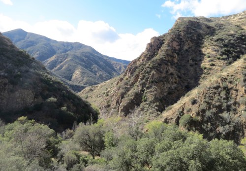
Created in 1978, Santa Lucia Wilderness covers 18,593 acres within Los Padres National Forest and another 1,893 adjacent acres that’s managed by the Bureau of Land Management. The relatively remote wilderness area is located in San Luis Obispo County and has just three hiking trails, which are about two hours from Santa Barbara.

The wilderness features several scenic waterfalls and two trail camps, which provide great opportunities to explore the southernmost reaches of the Santa Lucia Mountains.

A hike to Big and Little Falls can make for an engaging day trip. Both waterfalls are relatively close to their respective trailheads, however the main challenge is the road in, which requires a high-clearance vehicle because of the numerous creek crossings. In fact, the best to time go is late spring when the water is typically lower.

A hike to Little Falls is about a mile round trip and a hike to Big Falls is about two miles roundtrip. A loop hike of about nine miles can be made that connects Big Falls and Little Falls Trails and provides a way to see more of the area.

To get to the trailhead from Santa Barbara, take Highway 101 north to Arroyo Grande and exit at Grand Avenue. Take Grand Avenue through old town Arroyo Grande and turn right on Huasna Road, which more or less turns into Lopez Drive.

Continue on Lopez Drive towards Lake Lopez Recreation Area. The road crosses Lopez Dam, before arriving at the entrance to the recreation area. The recreation area, with over 350 campsites ranging from car camping to full hook-up for recreational vehicles and trailers, is one way to combine the day hike with some easy camping.

Just before the entrance to the recreation area, the road branches. To reach the falls, stay to the right and follow Hi Mountain Road a short way to Upper Lopez Canyon Road. Turn left on to Upper Lopez Canyon Road, which traces the eastern edge of the recreation area as it makes its way into the national forest.

Where the paved road ends the route becomes more challenging because of the creek crossings. From this juncture it’s about a mile and half to the beginning of Little Falls Trail and the road crosses Lopez Creek seven times before arriving at the signed trailhead. The road ends another two miles upstream at the Big Falls Trailhead.

The unpaved road is a private access road open to visitors, but parking is only allowed at the trailhead for either Little Falls or Big Falls Trails. Please respect private property.

From the trailhead for Little Falls Trail, the trail immediately crosses the creek and makes its way up Little Falls Canyon. Here, the stand out plant is red stem dogwood. While fairly common throughout much of the Unites States, the plant typically prefers moist and wet areas and is rare to see in Santa Barbara County. However, here is it one of the dominant plants lining the creek.

As the trail continues upstream it passes through a striking meadow filled with ferns and patches of lupine. Just past the meadow the trail enters Santa Lucia Wilderness and it’s here that any thoughts I have about just the beginning of the trail being lined with poison oak begin to fade. Little Falls Trail appears to be the road less traveled, and while this is great for peace and quiet, the lighter amount of traffic has allowed the hearty plant to stretch itself out into the trail corridor.

Nevertheless, the canyon is strikingly lush, as it leads under a canopy of oaks. The trail is mostly level and easy to follow.

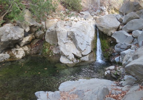
At about the half-mile mark, an informal side trail appears on the left at one of the creek crossings. Just past the crossing the trail climbs away from the creek. The side trail follows the creek a short way upstream, passing a small cascade before arriving at the base of Little Falls.

The moss-lined waterfall has a modest amount of water given the limited rain we’ve had this year. However, there is still a large, shallow pool of clear water at the base of the 50-foot waterfall and the scenic setting is ample reward for the hike so far.

Past the side trail to the falls, the trail climbs above the creek and becomes more exposed. Here, wild flowers flourish in the available sunlight. Along the trail are lupines, poppies, china houses, larkspur, monkey flowers, phacelia, and blue dicks.

The exposed section also provides a respite from the poison oak, before returning back down to the creek corridor.

Pausing at one of the creek crossings, I notice dozens of California newts cavorting in the creek. The newts, which are distinct from Sierra newts, are found only in counties along the coast in California. From December to early May, the newts will typically return to the pool where they hatched to reproduce. Newts secrete a strong neurotoxin and as a result have very few predators, which is probably why they’re largely unfazed by my presence.

Continuing upstream the canyon starts to narrow and the trail begins to make its way out of the canyon and towards the top of the mountains. As the trail climbs out of the canyon and becomes more exposed, the plants transition into chaparral including ceanothus, chamise, and black sage.

At about the 2.5-mile mark, Little Falls Trail arrives at Hi Mountain Road. Just across the road, to the north, is Rinconada Trail. Rinconada Trail represents an alternate way to reach the falls from the backside of the mountains, particularly when Lopez Creek is too high to easily cross. The trail is accessed from Pozo Road near Santa Margarita Lake.

Hi Mountain Road traverses the top of the mountains and offers great views back down into the canyon. The unpaved jeep road is also accessed from Pozo Road and ends at the top of Big Falls Trail.

From the top of Little Falls Trail it’s about a mile and a half west to the top of Big Falls Trail to continue the loop hike.

From the road, Big Falls Trail descends down into Big Falls Canyon and quickly reenters Santa Lucia Wilderness, passing through several scenic hillside meadows before returning into oak woodland.

The trail then arrives at the first creek crossing, which features several shallow pools. Here, western pond turtles compliment California newts as the noticeable wildlife in the creeks. Not possessing a strong neurotoxin like the newts the turtles waste little time disappearing.

A little further down, the trail arrives at a series of medium-sized pools as the creek carves its way through sandstone. Just past these scenic pools the creek plunges over a rock wall and then over Big Falls.

The trail continues down towards the base of the 90-foot waterfall. Again the amount of water is modest, but the large pool at the base of the falls is inviting enough that I feel obliged to go for a swim.

Relaxing after the swim and savoring the rest stop, my mind wanders, freed from the activity of hiking. At the far side of the pool I sense some movement and look to see three turtles stealthily surfacing near a large willow branch in the creek. They silently make their way onto the branch to sun themselves, content in a world of their own.

From Big Falls, the trail continues downstream towards the lower falls passing several little cascades before pulling away from the creek.

Although Big Falls Canyon provides the same opportunities for poison oak to flourish as Little Falls Canyon, the heavier traffic along the trail helps keep it from crowding into the trail corridor. Perhaps it’s the combination of swim holes and waterfalls that make this the more popular route.

The trail then returns to the creek and arrives above the lower set of falls. Visible from the trail is a pool tucked into the canyon below what could be described as the middle falls. The pool requires a bit of rock scrambling to reach from the base of the lower falls.

The lower waterfall is about 50-feet tall and can be reached from a short side trail that leaves the main trail.

From here, it’s a quarter of a mile downstream to the Big Falls Trailhead and Upper Lopez Canyon Road.

Big Falls Trailhead, at the end of Upper Lopez Canyon Road, is also the parking area for Lopez Canyon Trail, the third trail in Santa Lucia Wilderness. Lopez Canyon Trail leads further up Lopez Canyon to Sulphur Pot and Upper Lopez Camps.

From the Big Falls Trailhead, it’s about two miles downstream and seven creek crossings along Upper Lopez Canyon Road back to the Little Falls Trailhead to complete the loop.

This article originally appeared in section A of the May 21st, 2018 edition of Santa Barbara News-Press

Little Falls Canyon Trail Santa Lucia Wilderness hike los padres national forest

Little Falls

Little Falls Canyon Trail hike Santa Lucia Wilderness Los Padres National Forest

Little Falls Canyon

Big Falls Canyon Trail Santa Lucia Wilderness Los Padres National Forest

Big Falls

Big Falls Canyon Trail hike Santa Lucia Wilderness Los Padres National Forest

Big Falls Canyon

Big Falls Canyon trail hike Santa Lucia Wilderness Los Padres National Forest

Cascade Big Falls Canyon

Big Falls Canyon Trail hike Santa Lucia Wilderness Los Padres National Forest

“Middle Falls”

Western pond turtle Big Falls canyon Santa Lucia wilderness Los Padres National Forest

Western pond turtle suns itself near Big Falls

Coast Live Oak Little Falls Canyon Santa Lucia Wilderness Los Padres National Forest

Coast Live Oak, Little Falls Canyon


Posted by: James Wapotich | May 14, 2018

Trail Quest: La Jolla Trail to Manzana Creek, Part 2

It was late afternoon by the time we’d reached Cedros Saddle. It had already been a full day of hiking overgrown trails and we still had several more miles left to go before we would reach Manzana Creek and camp.

Our day had started along Figueroa Mountain Road at the top of La Jolla Trail, where we descended down into Birabent Canyon. The hike down to Ballard Camp was relatively easy, but as the trail turns up a side canyon it starts to become more overgrown. In fact, the middle section of the trail up to Zaca Ridge rarely sees any visitors and requires a fair amount of bushwhacking and route finding in order to reach what’s referred to as the upper meadow. From there, conditions improve up to Zaca Ridge.

From the top of Zaca Ridge, we followed Zaca Ridge Road to the top of Zaca Spring Trail. Another overgrown and seldom visited trail, Zaca Spring Trail drops down the backside of Zaca Ridge, where it meets Cedros Saddle Trail.

Cedros Saddle Trail, which is in much better condition than the previous two trails, climbs up to the top of the next ridge, which overlooks Manzana Creek. The trail meets Catway Road just past Cedros Saddle.

Across the road from Cedros Saddle Trail is the beginning of Sulphur Springs Trail, which leads down to Manzana Creek.

The idea was to connect these various trails together and make a 15-mile shuttle hike starting from the trailhead along Figueroa Mountain Road, camping along Manzana Creek, and exiting near Nira Campground, along Sunset Valley Road. A useful map of the trails for the area is Bryan Conant’s map of the San Rafael Wilderness.

Although it wasn’t necessarily our intention to follow the trails of Ranger Edgar Davison on our first day, many of the trails around Figueroa Mountain were part of his patrol area. However, on the second day we would be visiting places along Manzana Creek referenced in his journal, including trying to find “Cascade Canyon”, which he had likened to a “miniature Colorado” because of its narrowness.

Davison was one of the first rangers in our local backcountry in what was then Zaca Lake and Pine Mountain Forest Reserve, the forerunner to today’s Los Padres National Forest. His patrol area included the trails between Figueroa Mountain down to and including Manzana Creek.

As part of his patrol route he would often ride the trail along Manzana Creek down to Sulphur Springs Trail and continue up and over Cedros Saddle to reach Zaca Lake. There he would meet with John Libeu, the district ranger who lived at the lake.

Joining me on this hike was Volunteer Wilderness Ranger Curt Cragg. It had been several years since either of us had hiked Sulphur Springs Trial, but we both recalled the trail as being overgrown.

From Catway Road, Sulphur Springs Trail makes its way down towards Manzana Creek. The trail starts off through a mix of manzanita, scrub oak, ceanothus, and other chaparral plants. The trail offers exceptional views of Hurricane Deck, stretching from Castle Rock to the White Ledge area, framed by the Sierra Madre Mountains.

The trail then crosses a private access road, which it also crosses two more times before joining the road for the final leg to Manzana Trail.

Although sections of the trail are overgrown and there is still plenty of poison oak, Sulphur Springs Trail is in much better condition than either us remember, thanks to the trail work of volunteers from Los Padres Forest Association.

As the trail descends into Sulphur Creek Canyon, it follows the intermittently flowing creek downstream through maple trees and other riparian plants, before transitioning into oak woodland and arriving at the road. From here, we continue a short way down the road to the intersection with Manzana Trail.

To the left, Manzana Trail continues downstream towards Manzana Schoolhouse and Sisquoc River. To the right, the trail continues upstream towards the trailhead.

As we continue upstream, the trail follows an easement along a private ranch road. Please respect private property. To the north of the road, across the creek, is the San Rafael Wilderness.

The unpaved road leads past a meadow with old farm equipment from when the Davis family first homesteaded here in the late 1800s. The apple orchard that once grew in the meadow is what gives the area its name, Manzana being the Spanish word for apple.

Knowing Horseshoe Bend will likely be full with campers, we camp about a mile downstream and with the weather not that cold, we forgo having a campfire.

In the morning, we continue upstream along Manzana Trail. Our first stop is Horseshoe Bend Camp. The large, curving meadow has three sites, one near the creek with a grated stove and picnic table, and two more in the meadow, one with a metal fire ring and the other with grated stove and a picnic table that seems to migrate between the two sites. During the spring, when the creek is flowing, there is an inviting swim hole near the camp.

Davison, more than a hundred years ago, also referred to the site as Horseshoe Bend in his journal. He served as a ranger from 1898-1909, before retiring.

From Horseshoe Bend, we continue upstream along Manzana Trail, pausing at the Pratt Homestead site. The site is at the end of a long meadow along the trail, before the second crossing past Horseshoe Bend. The only indicator of the site is the initials “E” and “F” carved on two oak trees by Eddie Fields, the Pratts’ stepson. The Pratts homesteaded there in the late 1800s, but didn’t prove up on their claim. When they moved out they sold their stove and other supplies to Davison, who used them for the cabin he built in Fir Canyon.

We then arrive at Coldwater Camp, which has three sites. A large one under a big oak tree, which features a picnic table and metal fire ring. A second site under a cottonwood tree, which also features a picnic table and metal fire ring. And a third, smaller site, with just a grated stove located at the edge of the meadow.

In his journal, Davison describes his day to day activities, including the places he visited. One entry that caught my eye was “Cascade Canyon”. Davison describes it as “being the narrow and precipitous outlet of two large canyons through the south wall of the Manzana.” In looking at a topographic map of the area, the only place fitting that description is a side canyon upstream from Coldwater Camp.

Past the camp, Curt and I leave Manzana Trail and make our way towards the creek to locate the mouth of the canyon.

The small creek is flowing and the canyon is lined with poison oak in places and narrow like Davison described. As we continue up the canyon, we can see where the creek has carved its way through conglomerate stone. Conglomerate stone is sedimentary rock that is made of rocks, or clasts, that have been cemented together by finer-grained material and in some ways looks like frozen riverbed material. Similar material is also found in Fish Creek Canyon, further up along Manzana Creek.

In all there are a half-dozen medium sized cascades and small pools, some of which are difficult to reach, that live up to the name Davison gave the canyon.

Back on Manzana Trail, we continue upstream and arrive at Potrero Camp. The camp has two sites, both shaded and each with a picnic table and metal fire ring. The first camp we pass is on the north side of the creek, just before the trail juncture with Potrero Trail, which leads up to Hurricane Deck. The second site is on the south side of the creek, past the trail juncture.

Past Potrero Camp, Manzana Trail climbs away from the creek and follows the contours of the canyon upstream to the trailhead, completing the shuttle hike.

The trailhead for lower Manzana Creek is reached from Santa Barbara by taking State Route 154 over San Marcos Pass to Armour Ranch Road. From Armour Ranch Road, turn onto Happy Canyon Road and follow it up to Cachuma Saddle, where it meets Figueroa Mountain Road at a four-way intersection. Continue straight as Happy Canyon Road becomes Sunset Valley Road, which ends at Nira Campground. The campground is about a half-mile past the trailhead for lower Manzana Creek.

Horseshoe Bend Manzana Creek Trail backpacking hiking San Rafael Wilderness Los Padres national forest

The Meadow at Horseshoe Bend

Swim hole Horseshoe Bend Manzana Creek Trail San Rafael Wilderness backpacking hiking los padres national forest

Swimhole at Horseshoe Bend

This article originally appeared in section A of the May 7th, 2018 edition of Santa Barbara News-Press

waterfall cascade canyon San Rafael Wilderness Los Padres national forest Manzana Creek

Small waterfall in Cascade Canyon

Cascade Canyon San Rafael Wilderness Los Padres national forest manzana creek trail

Cascade Canyon

Cascade canyon manzana creek san rafael wilderness los padres national forest

Cascade and Pool, Cascade Canyon

Manzana Creek Los Padres National Forest San Rafael Wilderness

Manzana Creek


Posted by: James Wapotich | May 10, 2018

Trail Quest: La Jolla Trail to Manzana Creek, Part 1

We got our second wind half-way up Cedros Saddle Trail. It had been a somewhat demanding hike connecting together several overgrown trails that rarely see visitors.

The idea had taken hold a couple years ago when I was able to locate the middle section of La Jolla Trail and thought it might be fun to hike the trail as part of overnight backpacking trip. The route I envisioned followed La Jolla Trail to the top Zaca Ridge and connected over to Manzana Creek using Zaca Spring, Cedros Saddle, and Sulphur Springs Trails.

The 15-mile hike would provide a chance to see some remote parts of the San Rafael Mountains, but would also require a fair amount of bushwhacking and route finding. It would also require two cars, one at the trailhead along Figueroa Mountain Road and the other near Nira Campground along Manzana Creek.

Needing a cohort, I immediately thought of Volunteer Wilderness Ranger Curt Cragg. Curt had not only expressed interest in hiking La Jolla Trail, but seven years ago had led a series of volunteer trail projects in the area around Zaca Lake, including Zaca Spring and Cedros Saddle Trails. The projects were organized by Santa Barbara County Outdoor Foundation, which he founded, and included the installation of signs at various trail junctures.

I figured that alone would inspire him to look past all the implied bushwhacking and route finding, but as an added inducement I mentioned we would also be visiting “Cascade Canyon” along Manzana Creek. I’d located the canyon on the map after reading Ranger Edgar Davison’s journal. Davison described the canyon as a “miniature Colorado” because of its narrowness.

Curt was up for the adventure. On the appointed weekend, a car was left near Nira Campground and we made our way to the top of La Jolla Trail.

La Jolla Trail is reached from Santa Barbara by taking State Route 154 to Los Olivos and turning onto Figueroa Mountain Road. The road follows Alamo Pintado Creek upstream through a broad valley and then starts its climb towards Figueroa Mountain. The trailhead for La Jolla Trail is about a half-mile past Figueroa Mountain Ranger Station and just before the turnoff for Catway Road.

From the trailhead, we quickly cover the first two miles down into the Birabent Canyon and arrive at Ballard Camp. The camp has two sites and can make for an easy overnight backpacking destination.

The canyon is tucked in against the San Rafael Mountains with water flowing intermittently in the creek year round. Growing along the shaded creek are maple, alder, willow, and sycamore, as well as plenty of poison oak.

About a half-mile below Ballard Camp, the trail turns up a side canyon and becomes more overgrown as it starts to make its way towards the top of Zaca Ridge. Here, we both observe a blaze mark on an oak tree; it’s a square cut with a half size rectangle on top of it. These types of blazes were once a common way to mark routes and can still be seen in the backcountry along a number of trails.

We follow the trail up the side creek. After about a quarter of a mile, the trail crosses the creek one last time and makes its way onto an oak-covered ridge that separates two side creeks. Continuing up the ridge we pass a second blaze on one of the oaks. Here, the trail starts to fade.

The trail was badly damaged during the 1993 Marre Fire, which burned more than 40,000 acres.

The first time I’d hiked the trail I’d made it this far, but couldn’t find where the trail continued. A few years later I’d heard someone had brushed the first set of switchbacks where the trail continues up the hillside. On a return visit, finding that small section of cleared trail was just enough to set me on the right path to get to the upper meadow where the trail is in much better shape.

We are already feeling the heat of the day as we start up the first set of switchbacks. The trail is overgrown with regrowth from the fire and much of the old tread is covered with loose ravel that has slid down since the fire.

As we continue, the overgrown switchbacks begin to disappear. We know the trail makes a short dog leg into the canyon to the west, before crossing higher up back into the canyon on the east side of the ridge. Rather than continue to scout around for the trail we opt to bushwhack up the ridge with the hope of intersecting the trail.

Curt is the first to locate the trail further up. Pausing there, I can’t help but enjoy the juxtaposition of bushwhacking and route finding in the backcountry, while being able to see the ridge where Figueroa Mountain Road runs and knowing that we’re not that far from the Santa Ynez Valley and civilization.

From here, we resume threading our way through the chaparral. Someone once said it’s not bushwhacking unless you’re crawling. We were definitely bushwhacking, fortunately there is only a handful of places where we had to crawl to get through the ceanothus.

At one point we pass an old wooden barrel encased in travertine that may have been used as a trough, although the spring above it is no longer flowing. After one final scramble up a brushy hillside we arrive at the upper meadow, a glorious respite from all the brush we’d just pushed through.

The trail follows the western edge of this little meadow, passing through some light chaparral, before continuing along the western edge of a much larger meadow. We aim for a large dead oak tree near the upper end of this meadow.

Here, the trail leaves the meadow and threads its way up towards the top of Zaca Ridge. The trail is more overgrown than the last time I was there, but is comparatively easy to follow.

At the top of the trail we arrive at Zaca Ridge Road and continue a quarter of a mile west along the road to the top of Zaca Spring Trail. Curt’s sign is no longer there, but we’re still able to spot the beginning of the trail.

The roughly mile-long trail starts out okay, making a couple of wide switch backs, but then quickly dissolves into a series of game trails threading through mostly canyon live oak and ceanothus. Curt’s GPS leads us up from where we are, but I recall the trail being lower down. Not finding anything higher up, we angle down into the canyon until we intersects what looks like the old trail. To the untrained eye, it’s little more than a well-used bear trail, but we both recognize it as what’s left of the trail and follow it down the canyon.

The first time I’d hiked this trail I was coming up from Zaca Lake and actually saw a bear. I was busy musing to myself that it seemed like the only ones hiking the trail were the bears and looked up to see one cutting down one of the switchbacks.

The bear was closer than I liked; I remembered my sister telling me once that animals generally prefer to avoid conflict, since it can cost them energy they have to recover or, worse, present the risk of injury. It occurred to me that if I didn’t change anything in my behavior maybe the bear would do the same. And so without breaking stride, we essentially walked past one another, each of us looking back over our shoulder wondering what the other was doing there, but content nonetheless to continue on our way without any unexpected problems.

As the trail continues down the canyon, it joins the creek and starts to become a little more defined and arrives at the intersection with Cedros Saddle Trail. Here, at last, we find two of the trail signs Curt installed.

Cedros Saddle Trail is also overgrown in places, but much easier to follow than Zaca Spring Trail. About halfway up, we pause to catch our breath just below a stand of cedars.

From here, we start to find our second wind as trail conditions improve. Although still uphill we make better time to Cedros Saddle. Cedros is Spanish for cedar and at the saddle is a stand of cedars mixed with pines and oaks.

The trail then arrives at Catway Road. Across the road is the top of Sulphur Springs Trail, our next trail in the series.

Sulphur Springs Trail leads down to Manzana Trail, which follows Manzana Creek upstream to the trailhead near Nira Campground to complete the shuttle hike.

La Jolla Trail Birabent Canyon hike backpacking blaze mark Zaca Ridge Los Padres National Forest

A blaze marks where the trail turns up a side canyon

La Jolla Springs Trail Birabent Canyon Zaca Ridge hike backpacking Los Padres National Forest

Curt hiking along the middle section of La Jolla Trail

This article originally appeared in section A of the April 30th, 2018 edition of Santa Barbara News-Press.

Ballard Camp La Jolla Springs Trail Birabent Canyon hike backpacking Los Padres National Forest

The meadow in Birabent Canyon near where the original Ballard Camp was located. Here, the trail turns up a side canyon on its way to Zaca Ridge.

Birabent Canyon La Jolla Springs Trail Alamo Pintado Creek Los Padres National Forest

The creek flowing through Birabent Canyon

La Jolla Springs Trail Zaca Ridge hike backpacking Los Padres National Forest

The upper meadow along La Jolla Trail

Posted by: James Wapotich | April 23, 2018

Trail Quest: Serpentine landscapes of the Figueroa Mountain area

It’s hard not to fall in love with the serpentine rocks found in our mountains. Sometimes smooth and shiny, sometimes brittle and crumbly, the blue-green rock is found in several locations in Santa Barbara County with some of the most accessible outcrops found along Figueroa Mountain Road.

Serpentine is the state rock of California and takes its name from its mottled pattern, which is sometimes reminiscent of snakeskin.

Recently, Santa Ynez Valley Natural History Society hosted a field trip into the mountains with geologist Susie Bartz and naturalist Liz Gaspar. We visited four sites along Figueroa Mountain Road and learned about serpentine rocks and soils, and the plants that grow on them.

Serpentinite Serpentine ultra mafic roch Figueroa Mountain Los Padres National Forest blue point

Serpentinite

Our first stop is a large outcrop of serpentine rock along the road between Sedgwick Reserve and the Midland School property. Here, we’re afforded exceptional views of Zaca Ridge, including Grass Mountain and Zaca Peak.

With this backdrop, Ms. Bartz explains how these rocks were formed, but not without first acknowledging the work of Thomas Dibblee; “Tom was a geologist who mapped the entire San Andreas Fault, out to 25 miles on its eastern side and to the coast on the western side. He mapped about 40,000 square miles on foot over his 75-year career.”

A friend of Mr. Dibblee, Ms. Bartz later helped bring his maps to publication. The maps, which are overlaid onto USGS topographic maps, provide a detailed overview of the geologic formations found in a particular area and are a great resource for understanding the geology of our local area. Dibblee maps can be purchased at Santa Barbara Museum of Natural History, as well as viewed online at https://ngmdb.usgs.gov/mapview.

Serpentine rocks are part of the Franciscan assemblage of rocks that can be found in a 35-mile long swath across our local mountains from Blue Canyon to Figueroa Mountain. The formation is bordered primarily on the north by Camuesa Fault and on the south by Little Pine Fault.

Franciscan rocks were formed 150-60 million of years ago as a result of the movement of the Earth’s tectonic plates. There are two types of plates, oceanic and continental, and as they move around and interact they meet at either a convergent boundary, where one plate dives under another, or at a transform boundary, where one plate slides past another along a fault such as San Andreas Fault.

Oceanic plates are formed at mid-ocean spreading centers that open as one plate dives under another. Because oceanic plates are thinner and denser they’re often subducted under less dense continental plates, slowly disappearing like a conveyer belt.

“What happens is a lot of bulldozing and scraping of all the stuff on the surface of the sea floor, which accumulates little by little on the underbelly of the edge of the continent,” Ms. Bartz explained.

This accumulation of material along the plate boundary is called an accretionary wedge and is a mix of rocks, including both sedimentary and metamorphic rocks. Metamorphic rocks are rocks that started out as one thing and have been chemically altered by heat and pressure.

susie bartz ranger peak serpentine santa ynez valley natural history society los padres national forest camuesa fault

Geologist Susie Bartz points out Camuesa Fault on the landscape near Ranger Peak

Ms. Gaspar in turn highlighted the work of Arthur Kruckeberg, who was among the early researchers to focus on the flora and ecology of serpentine soils in California. She then led us on a short walk where we could see the disparity between plants growing on serpentine soils versus non-serpentine soils.

“Everything is turned upside down with regard to what plants need,” Ms. Gaspar pointed out. “Plants need a high ratio of calcium to magnesium, but on serpentine soils it’s the opposite, magnesium is high and calcium is low. Serpentine is also low in phosphorous, nitrogen, and potassium, which plants need.”

Plants growing on serpentine soils not only have to tolerate these nutritional deficiencies but also heavy metals such as nickel, iron, and magnesium. And yet, nature has found a way to use serpentine soils, with plants evolving over time to tolerate and even thrive on them.

Serpentine formations cover just 1.5 percent of California’s total land area, but account for 11 percent of California’s endemic species, that is, plants that are only found in California.

Our next stop is along an old road cut, about a mile before Figueroa Mountain Ranger Station. The unpaved access road may have been used for prospecting or mining and leads past a debris slide composed of serpentine rock, where Ms. Bartz explains how serpentinite is formed.

Surprisingly, one of the key ingredients in the formation of serpentinite is water, along with heat, pressure, and time. The parent rock for serpentinite is peridotite, which is formed deep within the Earth’s crust near the mantle. It’s formed at mid-ocean ridges where sea water is able to find its way down into the Earth’s crust, slowly soaking the peridotite over millions of years.

The addition of water makes the rock lighter which brings it up towards the surface. As it’s driven past other rocks it’s not only exposed to additional pressure, but its surface is sometime pressed and scraped creating slickensides, which is what can give serpentinite its shiny appearance.

The addition of water also changes the lattice structure of peridotite as it alters to serpentinite. Whereas, peridotite is hard to break, serpentinite weathers more easily, forming soil that some plants are able to grow in.

One evolutionary pathway is that some plants have random mutations in their gene pool that make them “pre-adapted” to tolerating serpentine soils. As the plants on serpentine soils further adapt and diverge physically they can’t successfully reproduce with their original counterparts, becoming their own species or variety.

Another way plants can become restricted to serpentine soils is if their non-serpentine counterparts are out-competed by other species, leaving just the ones growing on serpentine soils. In Santa Barbara County we have four serpentine endemic species.

liz gaspar serpentine plants ranger peak trail santa ynez valley natural history society los padres national forest

Naturalist Liz Gaspar points out chaparral plants growing on serpentine soil along Ranger Peak Trail

Our third stop along Figueroa Mountain Road is at a grassy hillside across from an outcrop of serpentine rocks near the top of Davy Brown Trail. Here, Ms. Gaspar points out where Devil’s onion might be found. We haven’t had enough rain to see any, but the plant, with its pink-tinted white flowers typically blooms from April to June.

Another serpentine endemic is Santa Barbara jewelflower, which is found only in the San Rafael Mountains. An annual plant, it blooms from May to July. Its nearest relative is found further east in the Transverse Ranges where it mostly grows on granitic soil. The rareness of the plant highlights both the unique habitat provided by serpentine soil and the importance of protecting these areas.

The third endemic growing in our area is leather oak, which we’ll see at our next stop. All three of these are known as strict endemics, meaning 95 percent or more of them grow on serpentine soil.

The fourth endemic in our area is Sargent cypress. It is a broad endemic, meaning 85 to 94 percent of them grow on serpentine soils. Similar in appearance to juniper, the plant was first recorded in our area by local ranger Edgar Davison. Good examples of it can be found along Old Catway Jeep Road, which starts near Davy Brown Campground, and along Cuesta Ridge in San Luis Obispo County.

Plant distribution maps can be found online at Jepson Herbarium eFlora, http://ucjeps.berkeley.edu/eflora, and Calfora, www.calflora.org.

Our last stop is near Ranger Peak. From the top of Ranger Peak Trail we make our way down to the small saddle where the trail branches. From this intersection, we’re treated to a great view eastward out across the San Rafael Mountains and Santa Ynez Valley.

Visible on the landscape is a unique situation where a long break in the plants reflects the transition from Monterey shale to Franciscan rocks, which are separated by Camuesa Fault. North of the fault is chaparral and to the south are mostly grasslands.

From the saddle we hike down along the trail to where a mix of chaparral plants is growing on serpentine soil. Here, Ms. Gaspar points out scrub oak and has us study its leaves and overall appearance. She then points out the serpentine endemic leather oak and we repeat the exercise. Both oaks have stellate hairs on the underside of their leaves, however leather oak also has the small hairs on the topside and its leaf edges curve under.

It is interesting to consider that serpentinite was formed in the Earth’s crust, under the ocean, and is now near the top of the San Rafael Mountains; and not only were some plants able to adapt to serpentine soil, but in some cases are now found almost nowhere else.

Ms. Bartz will be leading a geology field trip in December to the Red Rock area and leads programs for NatureTrack, which connects kids with nature.

Ms. Gaspar worked as the park naturalist for 20 years at Cachuma Lake and is the co-author of Wildflowers and Other Plants of the Cachuma Lake Region. She leads field trips and is on the board of Santa Ynez Valley Natural History Society.

Founded in 2000, the non-profit, member supported organization provides natural history and environmental education through public lectures and field trips in the Santa Ynez Valley region. For a list of upcoming events and programs go to, www.syvnature.org.

This article originally appeared in section A of the April 23rd, 2018 edition of Santa Barbara News-Press.

Posted by: James Wapotich | April 7, 2018

Trail Quest: The Trails of Edgar B. Davison, Part 2

In 1891, the Forest Reserve Act was passed, which allowed the President to create forest reserves on land in the public domain to help protect timber and water resources.

Edgar B. Davison was instrumental, along with other local citizens, in pushing for the formation of what would become Pine Mountain and Zaca Lake Reserve. Davison’s articles in the local press about the reserve helped generate interest in the idea and his political contacts helped keep the proposal on track.

In 1898, Pine Mountain and Zaca Lake Reserve became the first and largest forest reserve in our area, encompassing more than a million acres and Davison became one its first rangers.

Big Flat Munch Canyon Trail hike Sunset Valley Davy Brown Campground Edgar Davison Los Padres National Forest

“Big Flat” along Munch Canyon Trail

Additional reserves were created in Ventura, Santa Barbara, San Luis Obispo, and Monterey counties that were later combined and eventually became what is now known as Los Padres National Forest.

Davison’s patrol area included the north side of Figueroa Mountain down towards and including Manzana Creek. With his pay, he was required to provide his own supplies, pack animals, and food.

Davison would bring in supplies from Ballard by wagon as far as he could and then ride up one of the canyons on the front side of Figueroa Mountain until he reached the top of Ranger Peak, which at that time was known as Mount Bliss.

From there he would ride down through Munch Canyon to the cabin of C. E. Munch, which he used as a headquarters. In his first years as a ranger, Davison built the trail through what is now known as Fir Canyon, providing a better route over the mountains. Near the top of Fir Canyon he built a cabin, which he used in addition to Munch cabin depending on which area he was working in.

A variety of loop hikes can be made using the network of trails on the north side of Figueroa Mountain. A hike from the top of the mountains near the backside of Ranger Peak, down through Munch Canyon and returning through White Rock Canyon is about nine miles roundtrip and provides a chance to see some of the trails Davison patrolled.

To get to the trailhead from Santa Barbara, take State Route 154 to Armour Ranch Road. From Armour Ranch Road, turn onto Happy Canyon Road and continue to Cachuma Saddle, where it meets Figueroa Mountain Road. Turn left onto Figueroa Mountain Road and continue to the top of the mountains and look for East Pinery Road on your right. A map of the trails around Figueroa Mountain can be found on Los Padres National Forest website, http://www.fs.usa.gov/lpnf, under Maps & Publications or here.

East Pinery Road is currently closed, but parking can be found at the pullout near the gate. Continue along the unpaved access road a short way to the beginning of White Rock Trail. The road provides great views out towards Hurricane Deck and the Sierra Madres Mountains, and to the east San Rafael Mountain. The route is shaded by a mix of canyon live oak, coulter pines, and bigcone Douglas fir.

Waterfall Munch Canyon Trail Figueroa Mountain Edgar Davison Ranger Los Padres National Forest

Small waterfall in Munch Canyon

East Pinery Road continues another mile past White Rock Trail where it ends in a loop. As part of his work, Davison planted pines along this ridge as well as along Zaca Ridge.

White Rock Trail leaves the road and descends down into White Rock Canyon transitioning into a mix of chaparral dotted with canyon live oak and coulter pines. As the trail continues it transitions from Monterey shale into serpentine rock and arrives at the site of chromite mine.

At the site, one can find a variety of mining equipment and dig holes. Further down along the trail are rusted bed frames, a water heater, stove, and refrigerator, and even the remains of a trailer that served as the base camp for the mining operation.

A short ways past the mine, the trail arrives at the intersection with Munch Canyon Trail. Continue left on Munch Canyon Trail as it heads west through mostly chaparral before joining Munch Canyon and continuing down the canyon.

Chromite Mine White Rock Canyon Trail Figueroa Mountain Los Padres National Forest hike

Equipment at Chromite mine in White Rock Canyon

The trail is slightly overgrown but still followable. Look for an off-trail route at one of the creek crossings that leads down to a small waterfall. It requires a bit of rock scrambling, but is not that far from the trail.

From here, Munch Canyon Trail starts to ride above the creek and soon arrives at the intersection with Munch Canyon Connector Trail which leads over to Fir Canyon. Davison built this trail to connect to the cabin and trails he built in Fir Canyon.

When Davison’s pay went from $60 to $75 a month in 1902, he felt he had the means to marry his sweetheart Grace Lyons, who was a schoolteacher in Ballard. The two were married in the church that was built by both their fathers. Both families were early Ballard pioneers.

The newlyweds honeymooned at the cabin in Fir Canyon, riding over the mountains from Ballard. In her book, Beans for Breakfast, Mrs. Davison recalls how a skunk moved into the cabin during their first week and from that point on the couple slept outside under the stars. Mrs. Davison would often join her husband on patrol.

A writer and historian, Mrs. Davison wrote a regular column for the Santa Ynez Valley News, as well as articles for the Santa Barbara News-Press, and is credited with helping create the Santa Ynez Valley Historical Society. She is also the author of The Gates of Memory, which describes the early days of the Santa Ynez Valley.

White Rock Trail Edgar Davison hike Figueroa Mountain Los Padres National Forest

Scenery along White Rock Trail

From the intersection with Munch Canyon Connector Trail. Munch Canyon Trail continues down Munch Canyon through mostly scrub oak and ceanothus, dotted with the occasional grey pine. As the trail continues it starts to follow an old road cut.

The trail then arrives at a locked gate, where it branches. To the left is the connector trail that leads over to Davy Brown Campground. The trail may have been built by Davison as he replaced the old trail through the canyon. As part of his patrol route he would often ride down the canyon to Manzana Creek, and from there either ride up through Lost Valley or down to Sulphur Springs Trail and over to Zaca Lake.

From the intersection, continue along Munch Canyon Trail to a second gate. Here, the trail arrives at the intersection with Sunset Valley Trail at the edge of large, open meadow dotted with valley oaks, which Davison called Big Flat.

At the lower end of the meadow is where C. E. Munch built his cabin. Munch homesteaded here but later gave up his claim. The land became part of the forest reserve and the cabin served as a base for Davison. The cabin was later removed, along with Davy Brown’s cabin, by the forest service.

Munch Canyon Trail continues across the meadow and meets Sunset Valley Road. The road was built in the 1930s by the Civilian Conservation Corps and leads from Cachuma Saddle to Davy Brown Campground and ends at Nira Campground along Manzana Creek.

From the meadow, continue along Sunset Valley Trail. The trail is mostly level as it continues up the valley under a canopy of oaks transitioning into ceanothus as it makes the final push out of the valley and arrives at Sunset Valley Road.

old car rusting jalopy wreck White Rock Trail hike Figueroa Mountain Los Padres National Forest

Rusting jalopy along White Rock Trail

From here, continue along Sunset Valley Road as it follows Fish Creek upstream to the White Rock Trailhead. From the trailhead, White Rock Trail follows one of the small tributaries of Fish Creek upstream, winding its way up the canyon. Along the way the trail passes the remains of a rusting, old jalopy that managed to get itself stuck there.

The trail then crosses over into White Rock Canyon and continues up the backside of the mountains before arriving back at the intersection with Munch Canyon Trail to complete the loop portion of the hike and make the return to East Pinery Road.

Davison retired from the forest service in 1909, to spend more time with his family. The Davisons had five children and often lived together in the mountains until the kids reached the age where they needed to go to school.

Davison became the caretaker of Oak Hill Cemetery in Ballard, planting the redwoods that are still growing there. The house where they lived in Ballard is still standing and recently became the county’s newest historical landmark.

Davison passed away in 1949. A plaque honoring his service can be found at the Fir Canyon cabin site and another at Oak Hill Cemetery.

It’s said that when people wanted to rename Mount Bliss after him, he instead suggested it be called Ranger Peak, in honor of the service given by all forest rangers.

This article originally appeared in section A of the April 2nd, 2018 edition of Santa Barbara News-Press.

Posted by: James Wapotich | March 31, 2018

Trail Quest: The Trails of Edgar B. Davison, Part 1

In 1891, the Forest Reserve Act was passed which allowed the President to create forest reserves on land in the public domain, the forerunners of today’s national forests.

In 1897, the Forest Service Organic Administration Act was passed, which defined how the reserves would be administered and the criteria for their creation. The purpose of the reserves was to protect and preserve timber resources and the water supply within those areas. The act also allowed for the hiring of rangers and other personnel to administer and manage the reserves, as well as opening the land to public use.

In 1898, Pine Mountain and Zaca Lake Reserve was the first reserve created in our local area. A year later Santa Ynez Reserve was created. In 1903, they were combined into a single reserve. In 1906, San Luis Obispo Reserve and Monterey Reserve were created. Two years later, forest reserves became national forests; San Luis Obispo Reverse was combined with Pine Mountain and Zaca Lake and Santa Ynez Reserve, to create Santa Barbara National Forest. In 1919, Monterey National Forest was added to Santa Barbara National Forest, and in 1938, its name was changed to Los Padres National Forest.

Ranger Edgar Davison Fir Canyon Davy Brown Trail Figueroa Mountain Los Padres National Forest

Section of trail orginally built by Edgar B. Davison through Fir Canyon

Among the duties of those early rangers was fire suppression as means to protect the local watersheds and resources. This included building and maintaining trails to provide access to the backcountry. They were also responsible for ensuring that no illegal grazing of livestock took place and that people with homestead claims within the reserves were fulfilling the requirements laid out in the 1862 Homestead Act.

In 1898, Ballard resident Edgar Billings Davison became one of the first rangers in our area serving in the Pine Mountain and Zaca Lake Reserve. He had helped build both the schoolhouse and church in Ballard.

His patrol area included the trails along the north side of Figueroa Mountain down to and including Manzana Creek.

Davy Brown Creek Trail Fir Canyon Figueroa Mountain Los Padres National Forest

Small cascade and pool along Davy Brown Creek

From Ballard, he would bring in his supplies by wagon to where the road ended or became impassable and from there load up his pack animals and ride up one of the canyons to reach the top of the San Rafael Mountains. From there his route typically led him over Mount Bliss, later renamed Ranger Peak, and down into Munch Canyon where he headquartered at the cabin of C. E. Munch.

At that time the route through Blue Canyon was considered inaccessible, but he found a way to build a trail through the canyon and later renamed it Fir Canyon, after the bigcone Douglas fir that can be found there.

Davison called the new route Blue Point Trail, likely a reference to the large out-cropping of serpentine at the top of the canyon. The trail is better known today as Davy Brown Trail and connects from Figueroa Mountain Road down to Davy Brown Campground.

Blue Point Fir Canyon Davy Brown Trail Figueroa Mountain Serpentine Los Padres National Forest

“Blue Point” near the top of Fir Canyon

About a mile from the top of the canyon, Davison built a cabin, which he also used as a base for patrol and trail maintenance, depending on which part of his area he was working in.

The cabin site, as well as the trails he built and patrolled can still be visited today. A hike along the length of Davy Brown Trail is about six miles round trip. The hike can be made into a partial loop hike with a visit over to Willow Springs, which adds another half-mile. A map of the trails around Figueroa Mountain can be found on Los Padres National Forest website, http://www.fs.usda.gov/lpnf, under Maps & Publications or here.

To get to the trailhead from Santa Barbara, take State Route 154 to Los Olivos and turn onto Figueroa Mountain Road and continue a mile past Figueroa Mountain Campground to the pullout for Davy Brown Trail.

Conifers fir canyon davy brown trail hike Figueroa Mountain Los Padres National Forest Santa Barbara County

Fir Canyon conifers

From the trailhead, the trail leads down into Fir Canyon and quickly enters a mixed forest of grey pines, coast live oak, canyon live oak, and bigcone Douglas fir, with an understory of ceanothus, manzanita, and scrub oak. It is a place of vitality that benefits from its elevation and location on the north side of the mountain. The creek has water flowing intermittently year-round, and along the creek are alder, willow, and maple, all of which make for spectacular scenery in the fall.

About a mile from the top of the canyon the trail arrives at the intersection with Munch Canyon Connector and Willow Springs Spur Trails, both of which were built by Davison. Here, on the west side of Davy Brown Creek, Davison built his cabin.

Nothing remains of the cabin, but there is a commemorative plaque set in a serpentine boulder marking the site.

As a ranger, Davison was paid $60 per month and was required to supply his own horse and pack animals, gear and supplies. He was expected to put in an 8-hour day doing patrol and trail maintenance. Housekeeping and time spent feeding and taking care of his animals was to be done after hours. He was also required to keep a daily diary of his activities and whereabouts, which he had to ride into town each month to mail to his supervisor for review.

In his first week as a ranger, Davison fought and controlled a fire burning in Fir Canyon. As part of his fire suppression activities, he would clear cones and needles away from the base of pine trees, as well as clear space between the trees. He also posted fire warning notices at various locations in town and along the trails.

Roberts' Miner Cabin Fir Canyon Davy Brown Trail Los Padres National Forest Figueroa Mountain

Roberts’ Cabin site in Fir Canyon

Continuing from the cabin site down through Fir Canyon, the trail soon arrives at a second cabin site. This one an old miner’s cabin, set against the hillside near a small clearing along the creek.

Here, the rock type changes from Monterey shale which dominates the upper portion of the canyon to serpentine related material. In the creek are rocks and boulders with a subtle blue color, which is likely how the canyon originally came to be known as Blue Canyon.

As the trail descends it starts to transition into chaparral and the views open up out towards Hurricane Deck. The trail is steep at times and can be a workout hiking back up.

At about the 2.25-mile mark, the trail arrives at the intersection with Willow Springs Trail. From here it’s less than a mile downstream along Davy Brown Trail to Davy Brown Campground.

Cascade pool Fir Canyon Davy Brown Trail Los Padres National Forest

Cascade and pool along Davy Brown Creek

Just past the intersection, look for a short side trail that leads to the creek. The trail arrives at the top of a medium-sized cascade and pool that usually has some water in it year round.

From here, Davy Brown Trial, starts to level out and can make for a pleasant hike, except for the poison oak, down to Davy Brown Campground.

Returning along Willow Springs Trail provides a chance to see more of Davison’s handiwork. The trail doubles back along the creek from the juncture and then follows a ridge between two side canyons as it steadily climbs uphill.

As the trail nears the spring, an empty water trough can be seen from the trail. It’s hard to tell if the spring is flowing or not, but just past the trough the trail arrives at the juncture with Willow Springs Spur Trail, which leads over to the cabin site to complete the loop.

From this juncture, Willow Springs Trail continues to the top of the San Rafael Mountains. The trail wraps its way around the mountain westward and ties into Catway Road. This mile-long section of trail was also built by Davison.

Hurricane Deck Davy Brown Trail Figueroa Mountain Los Padres National Forest

Hurricane Deck is seen from Davy Brown Trail

When Davison first started working as a ranger, the best route to Zaca Lake was to continue down Davy Brown Creek to Manzana Creek. And from there, follow Manzana Creek downstream to Sulphur Springs Trail and ride the trail to the top of the mountains at Cedros Saddle and continue down to the lake.

As part of his trail work, Davison built a more direct route from Willow Spring along the top of the San Rafael Mountains, likely following a route similar to Catway and Zaca Ridge Roads. The route he built with Ranger John Libeu cut across the southern face of Zaca Peak, just as the route still does today, and along Zaca Ridge and down to the lake.

In 1901, Davison was laid off as a ranger. He worked various jobs, while hoping to be reinstated.

A year later, not only was he reinstated, he was also given a raise. With a salary of now $75 dollars a month he felt he had the means to marry his sweetheart, Grace Lyons, who was a school teacher in Ballard.

The couple honeymooned at Davison’s cabin in Fir Canyon.

This article originally appeared in section A of the March 19th, 2018 edition of Santa Barbara News-Press.

Manzanita blossoms flowers Fir Canyon Davy Brown Trail Figueroa Mountain Los Padres National Forest Santa Barbara County

Manzanita blossoms

Posted by: James Wapotich | March 31, 2018

Trail Quest: Big Cone Spruce Camp

Sometimes you just have to roll with the punches when planning a backpacking trip. I had a planned a leisurely three-day trip with my girlfriend to Big Cone Spruce Camp along upper Manzana Creek, but scheduling challenges reduced our available time to two days.

With access to so much of the backcountry closed due to the Thomas Fire and related road closures it can be challenging to find a place to backpack to that doesn’t involve adding extra miles to the hike just to reach the trailhead or desired destination.

East Camino Cielo Road is closed east of Gibraltar Road, which limits easy access to the trail camps behind Santa Barbara and parts of the Dick Smith Wilderness. Rose Valley Road is also closed blocking off much of the Sespe Wilderness. And seasonal road closures have similarly limited access to other parts of the forest.

Manzana Trail creek canyon camp hike backpacking San Rafael Wilderness Los Padres National Forest

Scenery along Manzana Creek near Manzana Camp

One of the areas that has remained open and generally accessible is the San Rafael Wilderness and in particular Manzana Creek. The trail along the creek offers a variety of camps to choose from and can be used to access points farther in the backcountry for longer treks.

Not finding many alternatives to Manzana Creek and reluctant to give up our destination we opt to hike to Big Cone Spruce Camp as overnight trip and decide on an early start to give us the whole day to enjoy a more relaxed pace.

The trailhead for upper Manzana Creek is reached from Santa Barbara by taking State Route 154 over San Marcos Pass and continuing to Armour Ranch Road. From Armour Ranch Road continue along Happy Canyon Road. The route leads through scenic ranch country and on our drive we were treated to seeing two coyotes dash across the road, as well as a dozen deer grazing along side the road.

Happy Canyon Road crests over the San Rafael Mountains at Cachuma Saddle and continues down the backside becoming Sunset Valley Road. The road passes Davy Brown Campground and the trailhead for lower Manzana Creek before ending at Nira Campground and the trailhead for upper Manzana Creek. An adventure pass is unfortunately required to park at Nira.

Manzana Creek is a popular destination, with a half-dozen trail camps spread out over the length of the upper creek. In springtime, there is generally water in all of the camps. From Nira Campground, it’s about 14 miles roundtrip to Manzana Narrows Camp and about 19 miles roundtrip to Big Cone Spruce Camp.

Grey Ghost Foothill Digger Pine Manzana Creek Trail hiking backpacking San Rafael Wilderness Los Padres National Forest

A stand of gray pines is seen from Manzana Trail

From the trailhead, Manzana Trail quickly crosses the creek and leads through a mix of riparian plants along the creek and chaparral on the hillsides. Amongst the riparian plants are alder, sycamore, mule fat, and willow. And amongst the chaparral is ceanothus, manzanita, yerba santa, chamise, and yucca. Also in the mix is coast live oak.

Many of these plants can be seen along other trails, and so in some ways the stand out plant here is gray pine, which is fairly common along Manzana Creek. Gray pines are found throughout parts of California and recognizable by their branching trunk, that can give the tree a narrow y-shaped profile. Pine nuts from its relatively large cones are edible and were used by native people throughout much of California, including the Chumash.

Settling into our hike, we quickly cover the first mile to Lost Valley Camp. The camp has two sites each with a picnic table and metal fire ring and grill. The camp is near the beginning of Lost Valley Trail, which leads up to Hurricane Deck.

From here, Manzana Trail becomes generally more exposed, staying on the northern side of the canyon as it rides above the creek and crossing the creek just before arriving at Fish Camp. Fish Camp is about 2.5 miles from the trailhead and features two sites, each with a picnic table and metal fire ring and grill.

Canyon Wren Manzana Creek Fish Creek San Rafael Wilderness Los Padres National Forest

Canyon Wren

We take our first rest stop at Fish Camp and walk a short ways downstream to the swim hole found below the confluence of Fish and Manzana Creeks. It’s not quite warm enough for a swim, but a spirited canyon wren keeps us entertained hopping from rock to rock.

Continuing upstream from Fish Camp, the trail soon crosses the creek, and again climbs away from the creek, staying on the more exposed northern side of the canyon. The trail then descends back down to the creek and arrives at Ray’s Camp, which features a picnic table and metal fire ring and grill. The camp is about 4.5 miles from the trailhead and is named for local author and trails advocate Ray Ford.

Past Ray’s Camp, the trial generally stays closer to the creek, becoming more shaded and offering a lot of rich scenery to take in. The trail crosses the creek several times on the way to Manzana Camp and it is refreshing to see clear, flowing water here in the backcountry.

As we continue, the canyon starts to narrow, which lets us know that we’re about to arrive at Manzana Camp where we plan to take another rest stop.

Manzana Camp is about six miles from the trailhead and features two sites. The first site is near the creek underneath a large sycamore tree and features a picnic table. The second site is under a canopy of coast live oaks and lacks a picnic table. Both sites have a metal fire ring and grill.

From Manzana Camp, we continue another mile up to Manzana Narrows. The camp features four sites, three with picnic tables and all with metal fire rings and grills. The camp is situated under a mix of coast live oak, canyon live oak, and California bay laurel.

There is usually water year-round at Manzana Narrows Camp and in the springtime one of the more attractive features is the medium-sized cascade in the creek.

Waterfall pool Manzana Narrows Camp trail creek hiking backpacking san rafael wilderness los padres national forest

Cascade and pool at Manzana Narrows Camp

Past Manzana Narrows, Manzana Trail continues upstream another half-mile to the intersection with Big Cone Spruce Trail. Here, Manzana Trail leaves Manzana Creek and continues over towards South Fork Station and the Sisquoc River.

Continuing up Manzana Creek, Big Cone Spruce Trail takes on more of a wilderness feel. The trail becomes more overgrown and as we continue we start to see bear sign on some of the trees and bear scat with cherry pits along the trail that are likely from last fall when cherries were on the bear’s menu.

The plants also change, near the trail juncture is the last of the gray pines, while further up the canyon the trail arrives at the first stand of big cone Douglas fir, also known as big cone spruce. Mixed in are canyon live oak, with the two trees become more prevalent as the trail continues.

We manage to arrive at camp just at sunset with enough light to settle in. The lower camp has a picnic table and grated stove and is nestled under a mix of canyon live oak, California bay laurel, and big cone Douglas fir. Water can be found in the creek near camp year-round.

As a reward for our full day of hiking, I make tri-tip tacos with pre-cooked tri-tip from Whole Foods that I’ve packed in along with tortillas, cheese, and fresh cilantro and onions. For breakfast I’ve packed in fresh eggs and mushrooms to go with the cheese and onions for an omelet.

Manzanita blossoms flowers Manzana Creek San Rafael Wilderness Los Padres National Forest Santa Barbara County

Manzanita blossoms

In the morning we awake to the raucous sound of several Steller’s jay. Both Steller’s jay and western scrub jays are in the corvid family, which includes crows, ravens, and magpies, which in my mind goes a long way to explain why they seem to enjoy making so much noise.

Steller’s jay have a wide range of vocalizations, and even more impressive is their ability to mimic the sounds of other animals such as red-tailed hawks and other raptors. The ploy is used to chase off other birds from productive feeding areas.

Steller’s jay prefer conifer forests and other wooded areas and seem to favor areas with year-round water.

Before leaving the area, we visit the upper camp, which features a picnic table and grated stove. The camp is apparently a favorite of the bears as the table is scratched and there’s even hairs from where bear has used as a scratching post.

With more time on the hike out we notice that in this uppermost part of the canyon that a number of plants are already starting to flower. In bloom along the trail are California bay laurel, wild gooseberry, nightshade, and bush poppy.

Retracing our route back to the car, we feel renewed, in spite of the long miles.

This article originally appeared in section A of the March 5th, 2018 edition of Santa Barbara News-Press.

Western scrub jay Manzana Creek trail San Rafael Wilderness Los Padres National Forest Santa Barbara County

Western scrub jay at Fish Creek Camp

Posted by: James Wapotich | March 31, 2018

Trail Quest: Lake Lopez

Less than two hours from Santa Barbara, in San Luis Obispo County, Lake Lopez can provide a fun weekend getaway in our neighboring county to the north.

The lake provides a range of recreational opportunities, including camping, hiking, boating, and fishing.

The 4,276-acre recreation area features a network of trails that can be used to create a variety of loop hikes that offer views of the lake and its three main arms, Arroyo Grande, Wittenberg, and Lopez, which represent the three creeks that flow into the lake.

The two main loops that can be made are Duna Vista Loop, which lets you explore the peninsula between Wittenberg and Lopez arms, and the different trails east of the campgrounds, which can also be combined into a loop. The trails are open to hiking, mountain biking, and horseback riding.

Lake Lopez High Ridge Fire Road hike

Lake Lopez is seen from High Ridge Fire Road

A map of the trails, as well as information about day use, camping, and campsite reservations can be found on the San Luis Obispo County Parks and Recreation website, www.slocountyparks.org. Central Coast Concerned Mountain Bikers also has a useful map on their website, www.cccmb.org, as well as maps for several other popular hiking and biking destinations in San Luis Obispo County.

To get to Lake Lopez Recreation Area from Santa Barbara, take Highway 101 north to Arroyo Grande. Exit at Grand Avenue and continue east towards the mountains as Grand Avenue becomes Branch Street and leads through old town Arroyo Grande. Turn right on Huasna Road, which more or less turns into Lopez Drive as it continues up Arroyo Grande Valley. Lopez Drive continues to the park entrance, crossing the dam, and offering views of the lake.

Lake Lopez has over 350 campsites ranging from so-called primitive sites for car camping to sites with full hook-up for recreational vehicles and trailers. At the marina is a boat launch, as well as boat, kayak, canoe, and stand up paddle board rentals. The marina also features a store and bar and grill. The recreation area also includes a water park and ropes course.

In some ways the best time to go is during the off-season, from October to April, when there are less people there.

Lake Lopez Wittenberg Creek Duna Vista Loop Trail hike

Wittenberg Creek is seen from Duna Vista Loop Trail

A satisfying loop hike that can be made starting near the campgrounds is to follow Cougar Trail north to Escondido Spur Trail and take it up to High Ridge Fire Road, retuning back along Blackberry Springs Trail. The full loop is about five miles and offers a mix of ridge-top views and canyon scenery. Most of the trails are well-marked with signs and are in generally good condition.

Cougar Trail runs behind the different camping areas that are east of the main road. The trail meanders through a mix of coast live oak and chaparral, crossing a number of small side canyons. Escondido Spur Trail leads up one of these side canyons and as it climbs offers views out across the lake.

About a half-mile up from Cougar Trail, Escondido Trail crests out of the canyon and branches. A short side trail to the left follows the ridgeline to an overlook. The main trail continues east along the backside of the ridge and connects to High Ridge Fire Road, which traces the eastern edge of the recreation area and parallels Upper Lopez Canyon Road.

The old fire road is more of single-track trail and offers views of the lake and surrounding area. Continuing south on High Mountain Fire Road, the trail passes another old fire road that leads back down to the campgrounds, before then turning westward and arriving at a four-way intersection. At the intersection is the top of both Turkey Ridge and Blackberry Springs Trails, both of which lead back down to Cougar Trail.

Blackberry Springs Trail is perhaps the more interesting of the two. The trail leads through a small canyon, leveling out briefly in a small hidden vale, before continuing down. The area feels more lush than the other canyons thus far and there is a rich mix of plants as the trail leads under a canopy of oaks. Along the trail is coffee berry, elderberry, ferns, and even silk tassel. Lining parts of the canyon are wild blackberry and of course poison oak. Further down, under many of the oaks is wild gooseberry. The trail connects with Cougar Trail to complete the loop.

shell fossils Monterey shale Lake Lopez hike

Shell fossils in Monterey shale

The other scenic loop that can be made is Duna Vista Loop, which follows the trails on the peninsula across the lake from camping areas. The full loop, including the two spur trails, is about 10 miles. The trailhead is reached by continuing along the main road, past the campgrounds, to the end of the paved road where there is a pullout for parking.

From there, continue about a mile along the unpaved road towards Camp French, which is managed by the Boy Scouts. The road essentially traces the edge of Wittenberg Arm before crossing the creek. Stay to the left as the road branches, which leads you past the Event Center. From there, continue across the open flat above the creek towards the beginning of the signed single-track trail.

The single-track trail continues downstream above Wittenberg Creek and leads through a mix of oak and chaparral. In the small side canyons, there is coffee berry, elderberry, sycamore, and some poison oak. In the more exposed areas there is chaparral with predominantly coastal sagebrush and the occasional lupine. Amongst the oaks are coast live oak and valley oak, with many of them featuring lace lichen dangling from their branches.

At about the 1.25-mile mark from the beginning of the single-track trail, the trail branches for the beginning of the actual loop. Staying to the left provides the shorter route to the two Duna Vista Lookouts, if one wants to shorten the hike.

From here, the trail starts its climb to the top of the ridge that separates Wittenberg and Lopez Canyons, and forms the long peninsula between these two arms of the lake.

Lake Lopez Duna Vista Loop Trail hike

Lake Lopez is seen from Duna Vista Loop Trail

As the trail climbs it offers views out across the lake. Here, the plants start to include toyon, ceanothus, and black sage. The trail then crests the top of the ridge and offers some great views out across the Lopez Arm of the lake and towards the ocean.

Here, the trail branches again. To the left, Duna Vista Spur Trail continues south another mile to Duna Vista Spur Lookout, which overlooks the dam. To the right, the main trail continues north along the ridge to complete the loop.

The trail to Duna Vista Spur Lookout has what feels like the most forested sections along the ridge, passing through toyon, oak, ceanothus and in some areas holly-leaf cherry and tanbark oak. The view from the overlook includes the dam, as well as Arroyo Grande Valley, Arroyo Grande, and the Oceano Dunes.

Construction of Lopez Dam began in 1967 and was completed in 1969. The dam was built to prevent flooding in the valley below, with the reservoir providing water for Arroyo Grande and the Five Cities area. The lake is currently at 50 percent capacity.

Continuing back along the ridge between Wittenberg and Lopez Canyons, the trail climbs to its highest point along the ridge, passing a second lookout spot, which offers views of both arms of the lake from a single vantage point.

The trail then starts to descend along the ridge, arriving at the juncture with the trail for the return loop and the beginning of Encinal Spur Trial, which leads down to the lake in Lopez Canyon.

Encinal Camp Lake Lopez hike oaks

Oaks near Encinal Camp

Encinal Spur Trail is definitely the least used trail on the peninsula. The slightly overgrown trail descends a half-mile down towards the lake and provides numerous opportunities to maneuver around poison oak. Near the lake, the trail arrives at a sign for Two Waters Trail, the previous name for Duna Vista Loop Trail.

At the sign, turn right and continue to Encinal Camp, which is situated in a large grove of coast live oak. The camp features a metal fire ring and grill and two picnic tables. Reservations for the campsite, which is only accessible by boat or along the trail, need to be made by calling the rangers at Lake Lopez.

From Encinal Camp, return back up to the trail juncture, and continue along the connector trail to complete the loop and return back to the trailhead.

Regardless of how far you hike you’ll get see a unique part of San Luis Obispo County.

This article originally appeared in section A of the February 19th, 2018 edition of Santa Barbara News-Press.

Posted by: James Wapotich | February 8, 2018

Backpacking Made Easy

backpacking class Santa Barbara Los Padres National Forest

*

backpacking class Santa Barbara los padres national forest

*

Through this class, you will learn the basic skills and awareness to set out on our local trails and craft your own backpacking trips. Many of these skills can also be used for day hiking as well.

This class is unique in that it takes place on our local trails, as the best place to learn something is in the context in which it applies–in this case outdoors, not in a classroom. You’re also probably interested in backpacking because you want to get out on the trails and experience nature more. 

Past participants have said: “James and Sierra make a perfect team. They made the richness of the backcountry accessible to me, even though I started with very little experience. They helped open me to a level of connection with nature I had never experienced.”

“The best part was the combination of practical skills and teaching around nature connection, as the two together inspired the confidence that I can do this.”

In general, the class covers three main areas: wilderness navigation; nature connection; and gear/trip planning.

Our approach to wilderness navigation is also somewhat unique. You will learn route-finding and orienteering skills that are not dependent on having a GPS or compass. While we do use these tools on occasion, knowing how to navigate without them can help build the confidence to hike anywhere.

Nature connection is also a big part of our time out on the land. The richness of the natural world is what makes it worthwhile to invest the time and energy to head out into the backcountry, the exercise from carrying gear for many of us is secondary. Feeling a deeper sense of connection and immersion in the elements is the often the real payoff for being outdoors.

We will cover the gear basics and provide insights into how to evolve your own gear set. You don’t need to buy the latest gear in order to head out into the backcountry; what’s more important is to have the basics covered so you can get out there and get started.

Backpacking Made Easy
Saturdays, March 24 – April 7

Santa Barbara and Ojai are home to a variety of incredible backpacking destinations, and yet, often the biggest obstacle is simply having the knowledge and skills to get started.

Through this immersive workshop, you will learn the basic skills needed to comfortably explore and enjoy our local trails.

Hot springs, waterfalls, epic views, and unspoiled wilderness are just some of the rewards for those who are willing to make the journey.

Each class takes place outside, on one of our local trails, and provides a mix of hands on instruction, immersive exercises, and sharing circles that allows for learning on many levels.

Lay of the Land
March 24th 9AM-3PM

Learn how to orient yourself to the local landscape, and begin learning the skills and awareness that will help you remove the word lost from your vocabulary. Become familiar with maps and creating your own mental maps and how to navigate without a compass or GPS. Learn about the different gear options and how to choose equipment that suits you.

Nature Connection
March 31st 9AM-3PM

Venturing out onto the land is even more enjoyable when we take time to develop a meaningful connection with it.

Learn to see the natural world around you as an ally, rather than an obstacle to overcome, and shift your hikes from feeling like endurance contests to journeys of discovery. Learn how to feel at home in the woods. Practical skills include trail navigation, menu planning, personal care and basic first aid skills.

Pathfinding
April 7th 9AM-3PM

Many of our local trails are overgrown, particularly those off the beaten path. Learn how to read the trails, practice route-finding, and develop your own sense of “body radar” to help you navigate in the wilderness. Practical skills include trip planning, campsite evaluation, water assessment, and camp set up.

Optional Free
Overnight Backpacking Trip
April 14-15

For those who are interested, we will help organize a free, optional backpacking trip. Here’s a chance to put all these great skills to use, and build on the material covered so far.

Length of the hike and destination for the overnight trip to be determined according to current conditions and the capabilities and interests of the participants.

Guides:

James Wapotich is a Volunteer Wilderness Ranger with the Forest Service and the author of the Santa Barbara News-Press hiking column, Trail Quest. James leads guided hikes and has hiked many of the trails in our local backcountry.

Sierra Boatwright is a UC Certified California Naturalist, council facilitator, and nature connection guide. An alumna of Pacific Crest Outward Bound School, Sierra has backpacked in the Appalachians, Sierras, and our local backcountry.

Workshop is $225 per person, or bring a friend and both 20% off.
Limit 12 students. Must be able to comfortably hike 3-4 miles.

To sign up or for more information please contact:

James (805) 729-4250 jwapotich@yahoo.com

Posted by: James Wapotich | February 8, 2018

Into the Mountains! Trails and Tales of the Santa Barbara Backcountry

Santa Barbara backcountry hiking backpacking los padres national forest trail rangers chumash vaqueros homesteads miners

*

Into the Mountains! Trails and Tales of the Santa Barbara Backcountry

Free Slideshow Presentation with Q&A

Wednesday, February 28th, 7:30PM – doors open at 7PM
Farrand Hall – Santa Barbara Museum of Natural History
2559 Puesta del Sol, Santa Barbara, CA

This talk will highlight several historic trails that lead from Santa Barbara into our local backcountry. Trails that can still be visited today as part of a day hike or backpacking trip and connect with the San Rafael and Dick Smith WIlderness areas. Trails highlighted will include those used by the Chumash, early settlers, mercury miners, cowboys, and early rangers. 

Join local author James Wapotich as he shares images and stories from his hikes and backpacking trips along these historic trails. James has hiked many of the trails in our local backcountry. He is a Volunteer Wilderness Ranger with the Forest Service, and is the author of the Santa Barbara News-Press hiking column, Trail Quest.

For more information call (805) 729-4250 or email jwapotich@yahoo.com

This talk is sponsored by Santa Barbara Audubon Society, for information about their upcoming bird walks, fields trips, and other events go to www.santabarbaraaudubon.org.

« Newer Posts - Older Posts »

Categories